Análisis de la app Maps Altimeter para 6 de diciembre
Maps Altimeter
- Amphebia
- Google Play Store
- Pagado
- Viajes y local
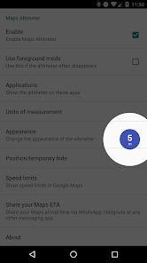
Maps Altimeter shows your current altitude on top of any app. It automatically detects when any app of your choice is active and shows an elegant overlay with a altimeter. It is also possible to show the altimeter when you connect to a Bluetooth device.
FEATURES:
- No advertisements!
- No internet access necessary, no backdoors sharing your private information;
- It automatically shows and hides if a chosen app is active or not;
- It automatically shows and hides, depending whether a Bluetooth connection is active;
- Choose between meters and feet (m and ft);
- Hide it for 10 seconds by touching the overlay;
- Adjustable transparency;
- Adjustable size;
- Adjustable colors;
- Adjustable text styles;
- Adjustable position, just drag it anywhere you like;
- Can be used with any app installed on your device
CONTACT US:
Please contact us if this application does not work properly on your device.
We will try to fix the problem for the next release.
This app uses Accessibility services. This app will only use Accessibility services to detect the current active app, so it can show the overlay with the apps chosen by you in the configuration.
Note: Android Auto is not supported. Unfortunately Google doesn't allow to show an overlay on Android Auto.
PERMISSIONS:
Display system-level alerts
This app will remain active in the background (no battery drainage) and shows an overlay on top the chosen apps when it is active.
Draw over other apps
With this permission Maps Speed Limits can draw the speed limit sign over other apps.
Precise location (GPS and network-based)
Necessary to read the location and speed from the GPS chip in your device.
Clasificación del uso de Maps Altimeter
El rango de uso se basa en el algoritmo de Similarweb que calcula las instalaciones actuales y los usuarios activos durante un periodo de 28 días.
Todas las categorías en
Alemania--
Viajes y local en
Alemania--
Intereses de los usuarios & Top categorias
Principales categorías y aplicaciones utilizadas por los usuarios de Maps Altimeter.
Categorías principales
Afinidad
Principales aplicaciones de la categoría
Más aplicaciones
48%
17%
7%
7%
Principales competidores & aplicaciones alternativas
Aplicaciones con una alta probabilidad de ser utilizadas por los mismos usuarios, desde la misma tienda.
Automile
Sun Seeker: Sunlight Tracker
6iciembre d, 2025