Sie haben Ihr Suchlimit erreicht
Starten Sie Ihren kostenlosen Testzugang, um weiterhin alle Traffic- und Performance-Insights zu erkunden.
Los geht'sAirportWX - METAR & TAF App-Analysen für 18. Februar
AirportWX - METAR & TAF
- Youri Berentsen
- Apple App Store
- Kostenlos
- Wetter
Your Complete Aviation Weather Companion
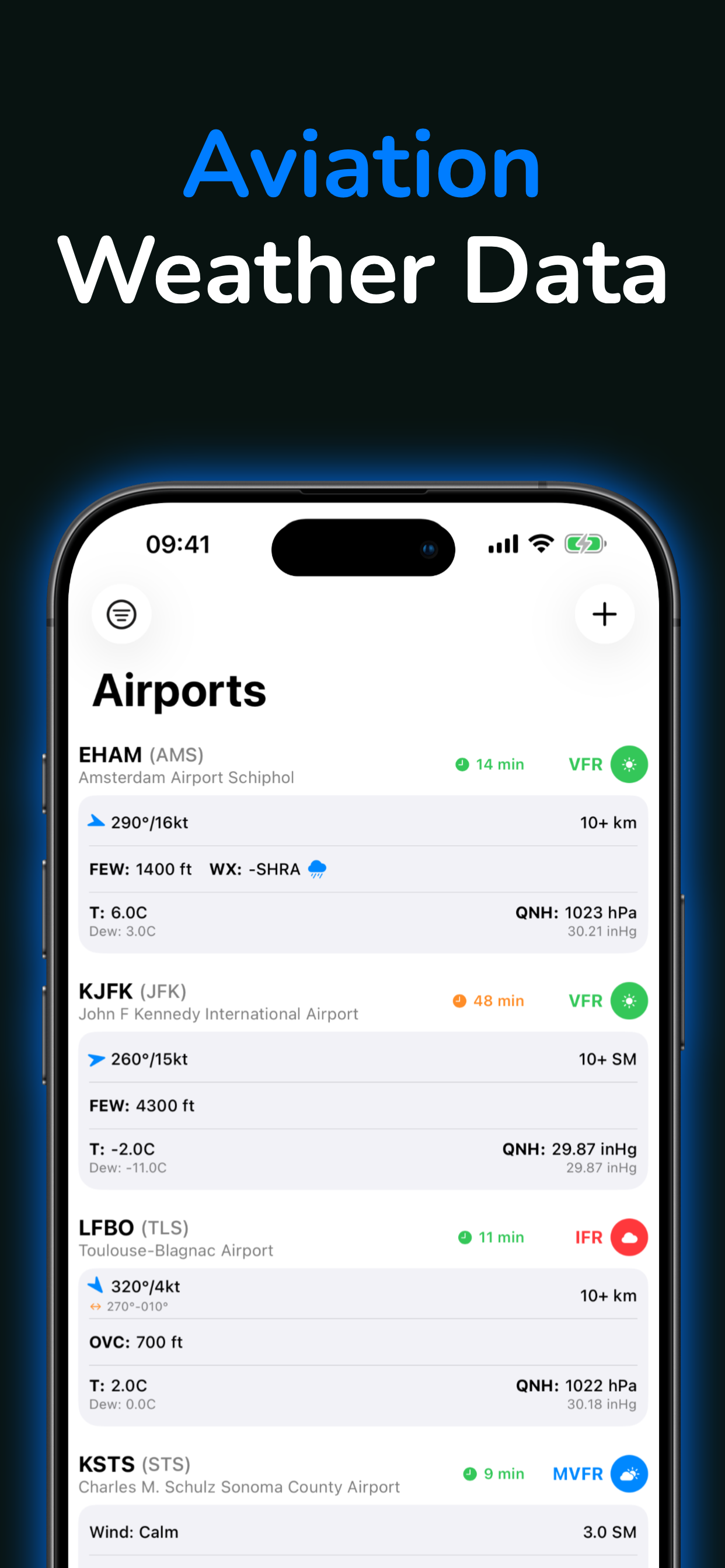
AirportWX delivers professional aviation weather data and essential pilot tools for over 48,000 airports worldwide. Whether you're a real pilot, flight instructor, aviation enthusiast, or MSFS flight simulator pilot, get instant access to decoded METAR and TAF data, interactive flight rules maps, and smart weather alerts - all in one powerful app.
REAL-TIME WEATHER DATA
- Decoded METAR & TAF - Aviation weather made easy to understand
- Live flight rules visualization (VFR, MVFR, IFR, LIFR)
- Wind speed, wind direction, and crosswind components
- Visibility conditions and ceiling heights
- Cloud layers and sky conditions
- Temperature, dewpoint, and altimeter settings
- Weather phenomena codes (fog, rain, snow, thunderstorms)
- QNH barometric pressure
- Runway conditions and surface wind
SMART WEATHER ALERTS
Never miss critical weather changes with customizable push notifications:
- Flight rules alerts (VFR, MVFR, IFR, LIFR thresholds)
- Wind speed and gust alerts
- Visibility threshold notifications
- Weather codes alerts (fog, thunderstorms, icing, snow, rain)
- One-time or recurring alert options
- Monitor multiple airports simultaneously
- Instant push notifications when conditions match your criteria
- Perfect for departure planning and arrival preparation
INTERACTIVE AIRPORT MAP
Visualize aviation weather across the globe with our powerful map view:
- Flight rules color coding - See VFR, MVFR, IFR, and LIFR conditions at a glance
- Real-time wind indicators showing direction and speed
- 48,000+ airports including ICAO and IATA codes
- Filter by airport size (large, medium, small airfields)
- Tap any airport for instant METAR, TAF, and detailed information
- Plan your flight route with live weather visualization
- Perfect for preflight weather briefing
COMPREHENSIVE AIRPORT INFORMATION
- Complete runway data including dimensions and surface type
- Taxiway and apron layouts
- Airport elevation and coordinates
- Airport type classification
- ICAO and IATA airport codes
- Airfield information
ESSENTIAL PILOT CALCULATORS & TOOLS
Professional aviation calculators for flight planning:
- Flight Time Calculator - Calculate flight duration
- Crosswind Calculator - Determine crosswind and headwind components
- True Airspeed (TAS) Calculator - Compute TAS from IAS
- Ground Speed Calculator - Calculate ground speed with wind
- Cloud Base Calculator - Determine cloud base height from temperature and dewpoint
- Humidity Calculator - Calculate relative humidity
Unit Converters:
- Temperature (Celsius, Fahrenheit, Kelvin)
- Pressure (hPa, inHg, mmHg)
- Fuel (Liters, Gallons, Pounds, Kilograms)
- Distance, Speed, and Altitude conversions
PERFECT FOR:
Private pilots and commercial airline pilots
Flight instructors and student pilots
Microsoft Flight Simulator (MSFS) enthusiasts
X-Plane and other flight simulator users
Drone operators and UAV pilots
Aviation meteorology students
Anyone interested in airport weather and aviation conditions
KEY FEATURES AT A GLANCE:
- Decoded METAR and TAF weather reports
- Visual flight rules map with real-time conditions
- Smart push notifications for weather alerts
- 15+ aviation calculators and conversion tools
- Comprehensive airport and runway information
- Wind, visibility, and cloud ceiling data
- Multiple airport monitoring
- Intuitive interface designed for pilots
- No ads, focused on aviation weather
AirportWX is for informational and educational purposes only. Always verify weather conditions through official aviation weather briefing services, ATC, and certified sources before flight operations. This app is NOT a substitute for official NOTAMs, weather briefings, or flight planning tools required for safe aviation operations. Pilots are solely responsible for all flight decisions and must comply with all applicable aviation regulations.
Terms of use: https://www.apple.com/legal/internet-services/itunes/dev/stdeula/
Rang speichern
Der Store-Rang basiert auf mehreren Parametern, die von Google und Apple festgelegt wurden.
Alle Kategorien in
Vereinigte Staaten--
Wetter in
Vereinigte Staaten--
Februar 18, 2026