Sie haben Ihr Suchlimit erreicht
Starten Sie Ihren kostenlosen Testzugang, um weiterhin alle Traffic- und Performance-Insights zu erkunden.
Los geht'sRunwayMap: Aviation Weather App-Analysen für 3. Mai
RunwayMap: Aviation Weather
- RedDev GmbH
- Google Play Store
- Kostenlos
- Wetter
RunwayMap is the #1 pilot community all about the passion of flying. You can view flight videos, reviews and photos from other pilots as well as share your flying experiences.
The interactive map gives you an overview of the airports. We have collected important information on every airport:
• Aviation weather forecasts
• Runways & NOTAM
• 3D and satellite views
• Webcams and much more
RunwayMap simplifies flight preparation and complements flight planning tools such as ForeFlight, Jeppesen and Garmin Pilot.
Download the versatile pilot app while you are at it.
Features:
MAP
Search by name or ICAO to discover new airports. Receive important information such as the current weather, address, position, runways, and sunrise/sunset. Mark and save what airports you’ve already flown to or those you’d like to fly to next. Save your personal notes for every airport.
AVIATION WEATHER
Current weather reports, visual flight conditions und wind forecasts are shown on our map.
ON-SITE SERVICES
Discover restaurants and hotels near the airport. Get informed about public transport and car rental offers.
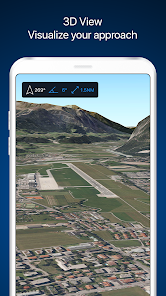
3D AND SATELLITE VIEWS
Check out the airport environment in 3D and satellite views. Use the OpenStreetMap view for detailed vehicle access information.
DOCUMENTS
With just a few clicks, add your flight documents, such as the Jeppesen approach charts, FAA terminal procedures and airport diagrams, Foreflight manuals or the Garmin pilot’s guide. That way you always have them close at hand.
TOOLS
Use the handy calculator for conversions for distance, weight, temperature, and more. Have it display your QNH and QFE.
RUNWAYMAP APP
Important note: RunwayMap is not intended to provide aeronautical information or navigation aids. For navigation purposes, we strongly recommend using only approved and updated aviation information such as ForeFlight, Jeppesen or Garmin Pilot.
The weather data shown in RunwayMap is only general information about possible weather development. It does not replace professional weather briefing by an official body before the flight.
Learn more about RunwayMap at runwaymap.com
RunwayMap: Aviation Weather-Nutzungsrang
Das Ranking der Nutzung basiert auf dem Algorithmus von Similarweb, der aktuelle Installationen und aktive Benutzer:innen über einen Zeitraum von 28 Tagen berechnet.
Alle Kategorien in
Vereinigte Staaten--
Wetter in
Vereinigte Staaten--
Top-Wettbewerber und alternative Apps
Apps mit hoher Wahrscheinlichkeit, von denselben Benutzer:innen aus demselben Store verwendet zu werden.
Airport Community
UNITED24
DFW Airport
Skiplagged - Exclusive Flights
Mai 3, 2026