Sie haben Ihr Suchlimit erreicht
Starten Sie Ihren kostenlosen Testzugang, um weiterhin alle Traffic- und Performance-Insights zu erkunden.
Los geht'sOpenRunner : bike & hike maps App-Analysen für 24. März
OpenRunner : bike & hike maps
- Openrunner
- Google Play Store
- Kostenlos
- Gesundheit und Fitness
OpenRunner, the outdoor application developed in Annecy at the heart of the French Alps, is your ultimate companion for creating, planning, and tracking your sportive and leisure outdoor adventures, directly from your smartphone!
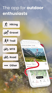
Whether you're passionate about cycling, mountain biking, trail running, hiking, horse riding, or even skiing, OpenRunner is the essential app for creating and exploring new routes. So, shall we plot together?
- Plot a route. Directly from your smartphone, you can easily, in just a few clicks, plot a route according to the activity chosen (running, trail running, hiking, cycling, mountain biking, Gravel…) that matches your current desires and abilities thanks to the real-time display of distance and elevation gain, mountain passes to cross, estimated time...
- Search for a route. Out of inspiration? Search and find the route that suits you among several million routes shared by the OpenRunner community! Filter by locality, distance, elevation gain, or activity to find the outdoor experience that suits you.
- Follow, record, share. OpenRunner gives you the ability to track your progress from your smartphone or your GPS device (watch, counter), whether you are following a trace or not, as well as to record your activity. Add photos, points of interest, comment, and share your route if you wish with other community members.
- Offline mode. When the network lets you down, OpenRunner does not, wherever you are! You can download maps for an offline use of the application.
- Safety first. With the LiveTrack feature, you will be tracked to the letter! LiveTrack is about reassuring and being reassured, setting out with peace of mind, safely, without worrying your friends and relatives... LiveTrack indeed allows them to follow your progress in real time on a map and to remotely check your position, speed, and altitude.
With EXPLORER, take it to the next level! Our subscription gives access to many features(*) that make route creation easier and enrich your experience. It's simple, everything becomes possible. You won't be able to do without it!
- Specialized and precise mapping worldwide: IGN France maps with 3 backgrounds available (Top 25, Scan 25 Tour and Plan v2), IGN Belgium, IGN Spain, Luxembourg, Norway, Sweden, Finland, SwissTopo...
- Unlimited map downloads by area or along a route for offline use.
- Route creation without distance or number of waypoints restrictions.
- Organizing routes into unlimited and customizable lists.
(*) Other features are available on the computer like Google Street View, adding POIs (points of interest), full-screen mode, setting a new starting point, multi-route display...
And if quality is present on OpenRunner, it's mostly thanks to all the user feedback! So for any questions, suggestions, or improvements, write to us at: app@openrunner.zendesk.com
OpenRunner : bike & hike maps-Nutzungsrang
Das Ranking der Nutzung basiert auf dem Algorithmus von Similarweb, der aktuelle Installationen und aktive Benutzer:innen über einen Zeitraum von 28 Tagen berechnet.
Alle Kategorien in
Vereinigte Staaten--
Gesundheit und Fitness in
Vereinigte Staaten--
Top-Wettbewerber und alternative Apps
Apps mit hoher Wahrscheinlichkeit, von denselben Benutzer:innen aus demselben Store verwendet zu werden.
eBike Flow
Campus Coach Running & Trail
Footpath Route Planner
Kiprun Pacer Running Plans
März 24, 2026