Sie haben Ihr Suchlimit erreicht
Starten Sie Ihren kostenlosen Testzugang, um weiterhin alle Traffic- und Performance-Insights zu erkunden.
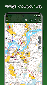
Los geht'sMaastokartat App-Analysen für 3. Mai
Maastokartat
- MapsiTech Oy
- Google Play Store
- Kostenlos
- Karten und Navigation
A free topographic map for outdoor adventures and exploring new places. See where you are and what's around you at a glance. Save interesting places and navigate to any destination. Maastokartat Plus unlocks additional features including detailed topographic maps with elevation and depth data, 3D maps, property boundaries, track recording and route planning, offline maps, cloud synchronization, and location sharing.
Free features:
• Accurate topographic map based on National Land Survey of Finland data
• Aerial imagery from the National Land Survey of Finland
• Nautical chart of Finland (Traficom)
• Worldwide satellite imagery
• Topographic maps of Sweden, Norway, Denmark, and Estonia
• Real-time location display and tracking
• Coordinate formats: WGS84, ETRS-TM35FIN, ETRS-Gn, YKJ, KKJ, and MGRS
• Compass with map rotation based on direction of travel
• Navigate to a destination with direction and distance display
• Place name and address search
• Distance measurement
• Save your own places
• Organize places and tracks into groups
• Share and import places and tracks as GPX files
• Backup to your personal Google Drive
• Heart rate monitoring with BLE heart rate sensors
Plus subscription additionally includes:
• Highly detailed topographic map with water depth information
• Hillshaded topographic map showing elevation differences
• 3D aerial and satellite imagery
• Worldwide outdoor map based on OpenStreetMap data
• Offline maps: download maps of selected areas to your device for use without an internet connection
• Cloud sync: automatically save your places and tracks to your account and keep them in sync across all your devices
• Record and display traveled tracks, plan routes in advance
• Draw areas and measure surface areas
• Share your location with other users, see their tracks drawn on your map
• Property boundaries and identifiers as separate map layers on top of other maps
The Plus subscription can be purchased as a one-time payment for €9.90 / 3 months or as a recurring subscription for €19.90 / year, which amounts to only €1.66 / month.
Maastokartat-Nutzungsrang
Das Ranking der Nutzung basiert auf dem Algorithmus von Similarweb, der aktuelle Installationen und aktive Benutzer:innen über einen Zeitraum von 28 Tagen berechnet.
Alle Kategorien in
Vereinigte Staaten--
Karten und Navigation in
Vereinigte Staaten--
Top-Wettbewerber und alternative Apps
Apps mit hoher Wahrscheinlichkeit, von denselben Benutzer:innen aus demselben Store verwendet zu werden.
Learn Swedish - Speak Swedish
CalTopo
TwoNav 6: Routes and Maps
TrekSpots | Tent camping map
Mai 3, 2026