Sie haben Ihr Suchlimit erreicht
Starten Sie Ihren kostenlosen Testzugang, um weiterhin alle Traffic- und Performance-Insights zu erkunden.
Los geht'sAltimeter App-Analysen für 29. April
Altimeter
- PixelProse SARL
- Google Play Store
- Kostenlos
- Tools
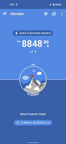
Altimeter is an handy Android application allowing you to get the true altitude above sea level (MSL) at your current location or any location on earth. It requires access to your device location to get raw altitude from the GPS signal and do not require a network connection to work. True altitude above mean sea level is determined using EGM96 Earth Gravitational Model. Main features are :
• Offline true altitude above sea level
• No network required (works offline and in flight mode)
• True altitude above sea level (AMSL using EGM96)
• Ordnance Survey National Grid reference system (OSGB36)
• Use Barometer or GPS Satellite
• Address at current location
• Save altitude at location
• Altitude accuracy estimation
• Horizontal accuracy estimation
• Altitude at any location
• Pick location on a Map
• Open photo geotags to display associated altitude
• Search for a location by name or address
• Universal Transverse Mercator coordinates (UTM)
• Military Grid Reference System coordinates (MGRS)
• Home screen widget to display altitude at current position
Network access is required to get the altitude of a location picked from the map.
Height above mean sea level (AMSL) is the elevation (on the ground) or altitude (in the air) of an object, relative to the average sea level datum. Normal GPS elevation considers the entire Earth as an ellispoid and differences up to 100 metres (328 feet) can exist between this ellipsoid height and true mean tidal height. The alternative, which is what we use in this application, is a geoid-based vertical datum such as the global EGM96 model.
Altitude vertical accuracy is defined at 68% confidence. Specifically, as 1-side of the 2-sided range above and below the estimated altitude reported, within which there is a 68% probability of finding the true altitude.
Enjoy!
Altimeter-Nutzungsrang
Das Ranking der Nutzung basiert auf dem Algorithmus von Similarweb, der aktuelle Installationen und aktive Benutzer:innen über einen Zeitraum von 28 Tagen berechnet.
Alle Kategorien in
Vereinigte Staaten--
Tools in
Vereinigte Staaten#2,677
Benutzerinteressen und Top-Kategorien
Top-Kategorien und -Apps, die von Altimeter Benutzern verwendet werden
Top-Kategorien
Affinität
Top-Apps innerhalb der Kategorie
Weitere Apps
15%
12%
10%
10%
Top-Wettbewerber und alternative Apps
Apps mit hoher Wahrscheinlichkeit, von denselben Benutzer:innen aus demselben Store verwendet zu werden.
WhatsGPS
Applied Ballistics Quantum
Weenect - GPS
Magic Earth Navigation & Maps
April 29, 2026