You’ve hit your search limit
Start your free trial to keep exploring full traffic and performance insights.
Get StartedSurvey and Coordinate análises de aplicativos para 27 de fevereiro
Survey and Coordinate
- Shin jong soon
- Google Play Store
- Pagos
- Ferramentas
This Measurement Application doesn’t need other notes or scientific calculator for measuring levels of something or EDM(Electric Distance Measurement device) measurement.
Capabilities of Measurement Application
. 36 languages are available(Korean, English, Chinese, Japanese, German,French,Spanish,Arabic,Hindi,Russian,Indonesian,Thai,Swahili,Vietnamese,Português,Malay,Urdu,Türkçe,Magyar,Nederlands,български,Ελληνική,Norsk,Dansk,Polski,Svenska,Italiano,Română,Slovenčina,українська,Čeština,hrvatski,Català,فارسی,বাঙালি,беларускі)
. Sound and operational(+-) support are available when there is the keypad input.
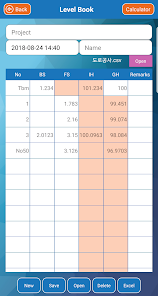
. When you enter a value of level, the ground level is displayed immediately
. If you enter the final height, the difference between the ground height and the final height is displayed automatically.
.The values of Level Measurement can be stored in the personal terminal and they can be saved as Excel file.
. Automatic numbering of station numbers in leveling (When entering the enter key)
. Excel file can be imported and inputted when inputting coordinate value (long touch)
.You can get the distance and azimuth( Degree, Gradian, Radian) of two coordinates.
.If you know the coordinates of one point and azimuth and distance, you can calculate the coordinates of different points.
.If you know the coordinates of two points, you can get all coordinates on a straight line between two points.
.If you know the coordinates of two points, you can easily obtain the rectangular coordinates between two points.
.The coordinates of the center of two coordinates can be obtained.
.If you know the coordinates of the two points, you can know the coordinates of the point that you do not know as a resection.
. The coordinates of the intersection of two straight lines can be obtained
. You can get the Coordinates(x,y,z) of Slope
. All the coordinates of a straight line can be extracted and used as desired intervals.
. All the coordinates of a circle line can be extracted and used as desired intervals.
. All the coordinates of a clothoid line can be extracted and used at desired intervals.
. Display of X(N), Y(E), Z and X(E), Y(N), Z
. Survey data can be shared
1. After downloading, select to share the file, open it in the app (survey) and save it
2. Paste the shared file to the app's storage folder
3. Android < ---- > ios
※ save path : Internal storage/Android/data/net.makewebapp.measurement/files/
Survey and Coordinate classificação de uso
A classificação de uso é baseada no algoritmo da Similarweb que calcula as instalações atuais e os usuários ativos ao longo de um período de 28 dias.
Todas as categorias em
Estados Unidos--
Ferramentas em
Estados Unidos--
Principais concorrentes e aplicativos alternativos
Aplicativos com alta probabilidade de serem usados pelos mesmos usuários, da mesma loja.
TreeMapper
ConstructionOnline
Leafplant: AI Plant Identifier
Mergin Maps: QGIS in pocket
fevereiro 27, 2026