You’ve hit your search limit
Start your free trial to keep exploring full traffic and performance insights.
Get StartedDougs Maps análises de aplicativos para 21 de fevereiro
Dougs Maps
- Forster Software
- Google Play Store
- Pagos
- Mapas e navegação
Latest complete "New Zealand" 1:50,000 topographic maps, "New Zealand" 1:20,000 cadastral (property) maps and Cook Islands topographic maps.
Map databases are based on up to date official open source data supplied by Land Information New Zealand (data.linz.govt.nz/data/) and the Department of Conservation (https://doc-deptconservation.opendata.arcgis.com/)
This app is not affiliated to the New Zealand Government in any way.
NZ topo maps show DOC boundaries with name of relevant area.
Easy to use GPS functionality.
Print maps to networked printer or pdf file.
No advertisements.
Download complete maps after installation of app (no additional cost). No internet or cellular connection needed after that.
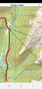
Vector maps are displayed on the fly from a database of map features. These maps scale nicely, are clear at any resolution and contain multiple layers of feature names appropriately sized to the displayed resolution. They rotate nicely and names flip to a readable orientation. The topographic maps are rendered with colours similar to traditional topographic maps. The property maps are rendered with custom colors. The property map shows public property in the green / blue areas (Conservation or local body) and yellow areas (public roads). You can easily see if you are currently on private or public land.
Most other mapping apps use raster data but our map data is more compact than raster data:
Topographic maps: 1.2 GB
Cadastral maps: 0.65 GB
Main map functions - all available offline:
· Turn on GPS logging with a simple menu touch.
· When the GPS is on see where you are on the map
· Drop a waypoint at your GPS location with a simple menu touch
· Search for a pre-loaded waypoint or track log
· Search for place name
· Search for street address
· Search by map coordinates. Can use NZTM or NZMG projections including 6 or 8 digit short coordinates and map reference if necessary. Or lat/long.
· Make a waypoint based on the above searches
· Create Goto line from current location to specified target to assist GPS navigation
· Optional voice navigation of user defined route or Goto line
· Proximity user waypoints with voice announcement.
User features (tracks and waypoints) can be added to the maps on the fly or by upload.
Main user feature functions:
· Tracks and waypoints can be imported from GPX files
· Store as many user features as you like in the user feature database.
· Waypoint created on the fly via press and hold context menu
· Move waypoint as required
· Create track on the fly via press and hold context menu and simple track drawing tools
· Track recorded by live GPS function
· Edit name, colour, notes, track format etc associated with user features
· Manage user features in bulk
· Export user features to GPX file
· Use desktop software to exchange user features directly with device via USB cable (supported by Freshmap V21 onwards at present)
· Exchange tracks and waypoints with a Garmin GPS via OTG cable.
· Exchange tracks and waypoints with another android device via offline wireless sharing
· View profile graphs of track features
· If online view user features on Google Earth
Dougs Maps classificação de uso
A classificação de uso é baseada no algoritmo da Similarweb que calcula as instalações atuais e os usuários ativos ao longo de um período de 28 dias.
Todas as categorias em
Estados Unidos--
Mapas e navegação em
Estados Unidos--
Principais concorrentes e aplicativos alternativos
Aplicativos com alta probabilidade de serem usados pelos mesmos usuários, da mesma loja.
Trippy Tour Guide
HiiKER: The Offline Hiking app
Walkbox Self-Guided Tours
Shaka Guide | GPS Audio Tours
fevereiro 21, 2026