2月18日 的 mapry林業 應用程式分析
mapry林業
- MAPRY Co., Ltd.
- Apple App Store
- 免費版
- 公共設施
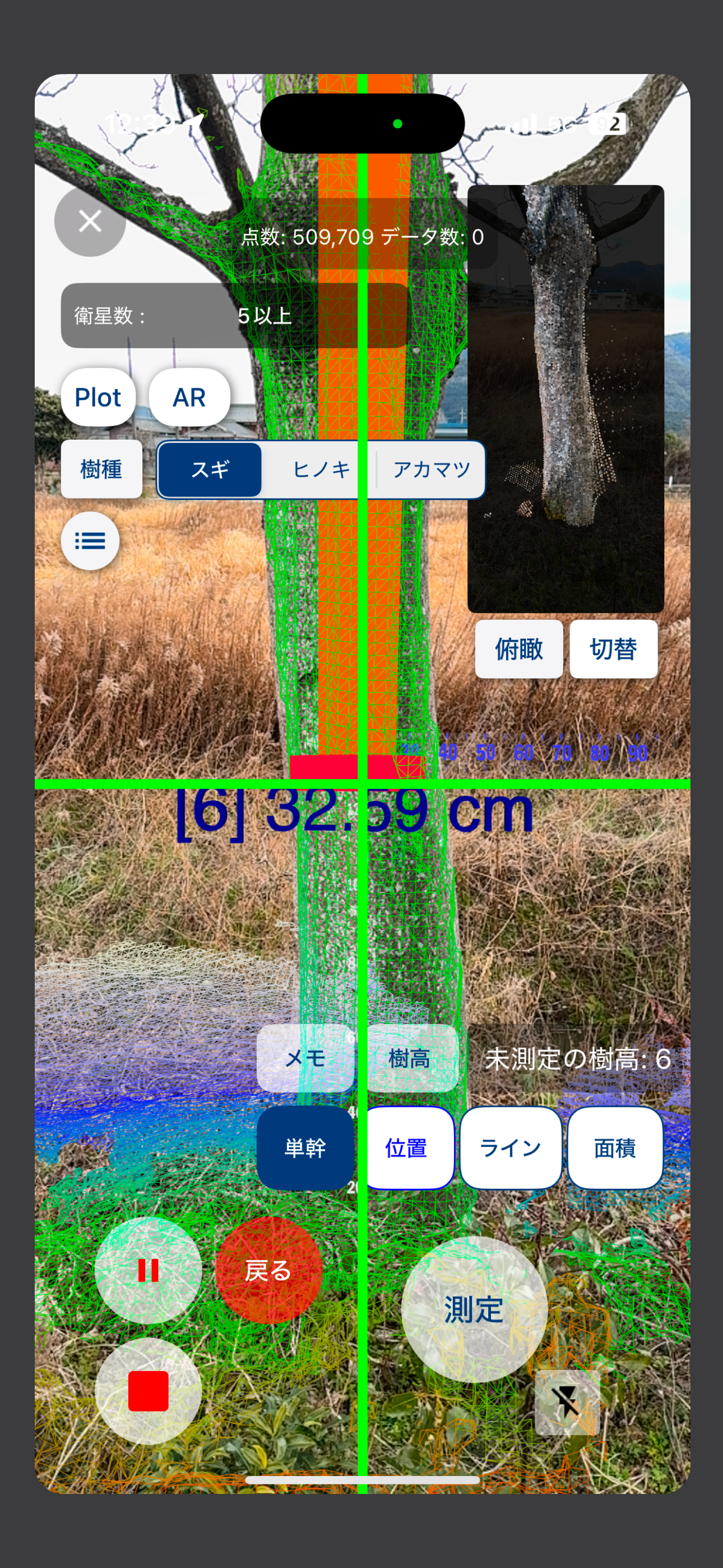
mapry林業はiOS mapryの地図機能をベースに、3Dスキャナー機能で撮影した点群を保存・表示できるアプリです。
3Dスキャナー機能で撮影中、単木へ+アイコンを合わせてタップすると単木の直径、経緯度等の単木情報を取得することが出来ます。
取得した点群と単木情報は、保存後に表示することができます。
■mapry
https://apps.apple.com/jp/app/mapry/id1394357769
■Web版
https://mapry.net
mapryの詳細については上記mapryの概要欄を参照ください。
mapryの機能そのままに、以下の機能が追加されています。
※3Dスキャナー機能は、設定-> サービス管理から「有料サービス」に変更することで使用することができます。
○3Dスキャナー
・樹種の一覧選択・編集
・タップした単木情報を取得
・取得した3D点群を保存
・保存した3D点群と単木情報の一覧を表示・編集
・保存した単木情報一覧をcsvファイルにして保存
_________________________________________________________
Based on the map function of iOS mapry, mapry survey is an application that can save and display point clouds taken with the 3D scanner function.
While using the 3D scanner function, you can acquire single-tree information such as diameter and longitude/latitude of a single tree by tapping the + icon on a single tree.
The acquired point cloud and single tree information can be saved and displayed.
■mapry
https://apps.apple.com/jp/app/mapry/id1394357769
■Web version
https://mapry.net
For more information on mapry, please refer to the mapry overview section above.
The following features have been added to mapry, without changing its functionality.
※The 3D scanner function can be used by going to Settings->Service Management and changing to "Paid Service".
○3D Scanner
・Select and edit tree species list.
・Tapped single tree information is acquired.
・Save the acquired 3D point cloud.
・Display and edit the list of saved 3D point cloud and single tree information.
・Save the list of saved single tree information as a csv file.
商店排名
商店排名基於Google和Apple設定的多個參數。
所有類別 在
美國--
公共設施 在
美國--
2月 18, 2026