
5月3日 的 Red Grid MGRS - Military GPS 應用程式分析
Red Grid MGRS - Military GPS
- Estus Holdings LLC
- Apple App Store
- 免費版
- 導航
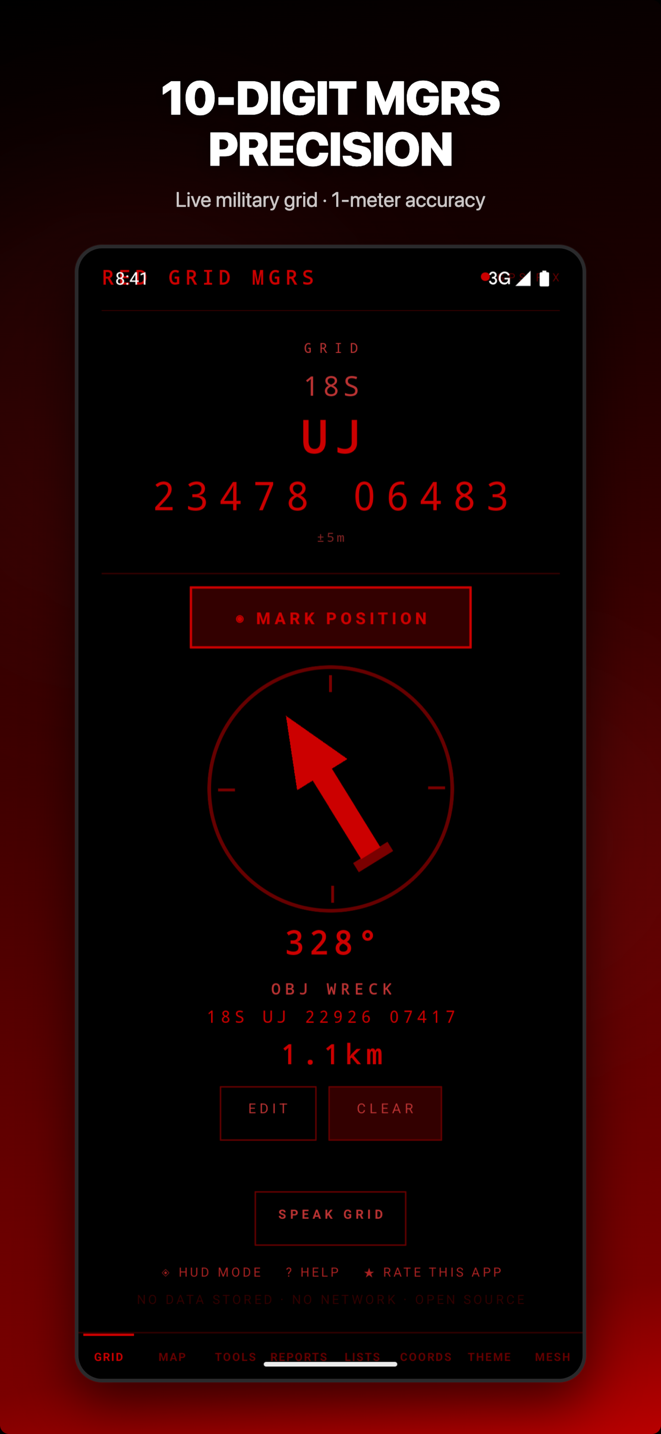
The military's DAGR (AN/PSN-13) costs $2,500 and weighs a pound. Red Grid MGRS puts the same core land navigation capabilities in your pocket — live 10-digit MGRS, magnetic declination, waypoints, bearing and distance — for free. No network required. No data collected. No accounts to create.
YOUR PHONE. DAGR CAPABILITY.
Like the Defense Advanced GPS Receiver carried by warfighters worldwide, Red Grid displays your Military Grid Reference System position in real time with 1-meter precision. But Red Grid goes further — adding offline tactical maps, Meshtastic mesh networking, NATO voice readout, tactical report generation, and pace counting that the DAGR doesn't offer.
OFFLINE TACTICAL MAPS:
- OpenStreetMap with MGRS grid overlay
- Download tiles for your area of operations
- Dark tactical tiles for low-vis environments
- Toggle offline mode for zero-network map use
- Works completely disconnected from any network
MESHTASTIC MESH NETWORKING:
- Share your grid position over LoRa mesh via BLE
- See other mesh users on the map in real time
- No cell service, no internet, no infrastructure needed
- Just Meshtastic radios and phones
DAGR-EQUIVALENT FEATURES:
- Live MGRS coordinates (4/6/8/10-digit precision)
- Magnetic declination (WMM model)
- Waypoint storage with bearing and distance
- Back azimuth and dead reckoning
- Speed, elevation, and heading display
- Multiple coordinate formats (MGRS, UTM, DD, DMS)
- Full offline operation — zero cloud dependency
10 TACTICAL TOOLS:
- Back Azimuth calculator
- Dead Reckoning plotter
- Two-point Resection
- Pace Count tracker
- Magnetic Declination reference
- Time-Distance-Speed solver
- Sun & Moon position data
- MGRS Precision selector (1m to 100km)
- Elevation & Slope calculator
- Photo Geostamp (MGRS/DTG burned into images)
6 RADIO-READY REPORT TEMPLATES:
Generate formatted reports ready to transmit over any net — a capability the DAGR hardware doesn't include:
- SALUTE (Size, Activity, Location, Unit, Time, Equipment)
- 9-Line MEDEVAC request
- SPOT report
- ICS 201 incident briefing
- CASEVAC request
- ANGUS/CFF fire mission
MORE CAPABILITIES:
- NATO phonetic voice readout (hands-free grid calls)
- HUD mode (full-screen tactical display)
- External GPS support (Garmin GLO, Bad Elf)
- GPX/KML import and export
- FixPhrase: open-source What3Words alternative
- Mission planning with route overlay
- 4 tactical display themes (red, NVG, day, blue)
- Haptic feedback for eyes-free operation
- 6 languages (EN, FR, DE, ES, JA, KO)
BUILT FOR OPERATORS:
Red Grid MGRS is designed for military personnel, search and rescue teams, law enforcement, wildland firefighters, first responders, hunters, and backcountry hikers who depend on accurate grid coordinates in austere environments. Whether you trained on a DAGR or a lensatic compass, Red Grid speaks your language.
ZERO FOOTPRINT PRIVACY:
- No accounts. No sign-up. No login.
- No cloud sync. No analytics. No tracking.
- No ads. No data leaves your device.
- Location data is held in memory only and never stored or transmitted.
Download free — includes live MGRS display, 1 theme, basic tools, and 3 report templates. Upgrade to Red Grid Pro for all 10 tools, offline maps, mesh networking, all themes, unlimited waypoints, and all 6 reports. Monthly, annual, or lifetime options available.
商店排名
商店排名基於Google和Apple設定的多個參數。
所有類別 在
美國--
導航 在
美國--
5月 3, 2026