
4月30日 的 HuntStand: GPS Maps & Tools 應用程式分析
HuntStand: GPS Maps & Tools
- Good Sportsman Marketing, LLC
- Apple App Store
- 免費版
- 體育
Your Edge From the Midwest to the Mountains
Discover HuntStand, now featuring a redesigned look and feel to enhance your scouting and navigation experience in the field — and introducing HuntStand Ultimate, our most powerful membership ever. Recognized by Outdoor Life Magazine as the Best App for Hunters, HuntStand is North America’s #1 Hunting & Land Management App with over 9 million downloads. Whether you’re glassing in the Rockies or setting stands in the whitetail woods, HuntStand is your ultimate hunting companion from the Midwest to the mountains. Install now for free!
► Popular Features ►
◆ Nationwide Property Lines: Search for property lines, access private and public boundaries, and view curated public land maps nationwide for all 50 states and most of Canada.
◆ Advanced Game Forecasts: Exclusive 15-day activity forecasts for whitetail, elk, mule deer, and blacktail at your exact location.
◆ Monthly Satellite Imagery: See changes in your hunting ground with monthly satellite updates plus years of historical imagery.
◆ Group Hunt Areas: Share hunt areas with buddies, lease partners, and family seamlessly.
◆ Exclusive Rut Maps: County-level rut maps for whitetail, elk, mule deer, and blacktail, with detailed dates for each phase.
► Start Mapping for FREE ►
Download HuntStand and start mapping your hunting areas today — completely free.
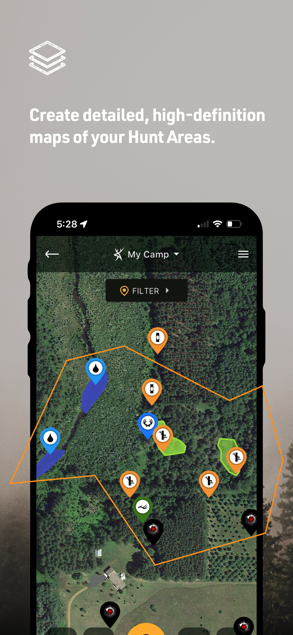
◆ GPS Mapping: View your location, track movement, and add markers for stands, blinds, and other key spots.
◆ HuntZone Wind Forecasting: Predict scent impact with hour-by-hour forecasts up to 72 hours ahead.
◆ Hunt Area Customization: Build and share detailed maps tailored to your hunts.
◆ High-Resolution Satellite: Navigate with crisp satellite imagery.
◆ Digital Rangefinder: Instantly calculate distances in the field.
► HuntStand Pro ►
$29.99/year – Premium mapping tools and nationwide coverage.
◆ Nationwide Property Lines: Detailed property line maps for all 50 states and most of Canada.
◆ Property Ownership Data: View landowner info and search by name.
◆ Monthly Satellite Imagery: Fresh updates and historical archives.
◆ Public Hunting Land Maps: Discover new hunting spots nationwide.
◆ National Aerial Imagery: High-resolution aerial maps for the U.S.
◆ 3D Mapping: “Fly through” terrain in dynamic 3D.
◆ Unlimited Offline Maps: Save maps for use without internet.
◆ Gear Store Discount: Save up to 20% on top hunting brands.
► HuntStand Ultimate ►
$99.99/year – Everything in Pro plus exclusive tools to give you the edge in the field from the Midwest to the mountains.
◆ All HuntStand Pro Maps and Tools.
◆ 15-Day Activity Forecasts: Peak activity times for whitetail, elk, mule deer, and blacktail.
◆ Advanced Rut Maps: Detailed rut dates for all four species.
◆ Whitetail Habitat Map: Identify top whitetail habitats (U.S. only).
◆ Gear Store Discount: Save up to 50% on top hunting brands.
Billing & Subscription: Charges apply to your iTunes Account upon purchase confirmation.
Privacy Policy: https://huntstand.com/privacy
Terms & Conditions: https://huntstand.com/terms-and-conditions
商店排名
商店排名基於Google和Apple設定的多個參數。
所有類別 在
美國--
體育 在
美國--
4月 30, 2026