
5月3日 的 German Topo Maps 應用程式分析
German Topo Maps
- ATLOGIS Geoinformatics GmbH & Co. KG
- Google Play 商店
- 免費版
- 地圖與導航
Offline GPS Navigation with Topographic Maps and Aerial Imagery for Germany
Powerful and easy-to-use outdoor navigation app with high-resolution topographic maps, official aerial imagery, and advanced navigation tools – ideal for hiking, cycling, and all outdoor activities.
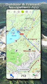
High-Resolution Maps for Germany
Access the best available map sources:
• Basemap LiDAR Hillshade: Based on official ATKIS Base-DLM data from the Federal Agency for Cartography and Geodesy (BKG), enhanced with fine hillshading
• DTK Topo LiDAR Hillshade: Official topographic maps (DTK series) with detailed shading
• TopPlus: Based on ATKIS Base-DLM data with an alternative cartographic style, also available across Europe (reduced resolution)
• Aerial imagery with up to 20 cm resolution
Discover even the smallest terrain features such as historic paths, foundations, or former border lines.
Worldwide Maps and Additional Layers
• AtloMaps Hillshading v4: High-resolution digital terrain model (1 m resolution)
• AtloMaps OSM: Topographic map based on OpenStreetMap data (often more detailed than official maps), with hillshading and global coverage
• CyclOSM: Cycling map
• ESRI Topographic, Aerial, and Street maps
• Google Maps, Satellite, and Terrain (online only)
• Bing Maps and Satellite (online only)
• Various overlays such as hiking and cycling routes, hillshade, and water features
More than 60 map types for Germany plus additional global maps available.
Regional Maps (German Federal States)
• Aerial imagery (10–40 cm resolution)
• Official topographic maps (DTK10, DTK25, DTK50, DTK100)
• Digital terrain models (DGM) and surface models (DOM)
• Cadastral maps (parcel maps)
• Additional overlays such as water networks and hiking trails
Compare and Combine Maps
• Combine multiple maps as overlays
• Compare maps using a transparency slider
• Choose the best map depending on region and use case
There is no single perfect map – compare multiple sources directly within the app.
Offline Maps and Navigation
• Download maps for selected regions
• Full offline usage without internet connection
• Automatic caching of viewed maps
• No roaming costs
GPS Navigation for Outdoor Activities
• Record GPS tracks (distance, speed, elevation, accuracy)
• Create and manage waypoints
• Navigate directly to waypoints
• Measure distances and areas
• Tap the map to get elevation and distance
• Track replay
• Customizable data fields (e.g. compass, distance, bearing)
• Search for places and addresses
• Coordinate formats: WGS84, UTM, MGRS
Import and Export
• Import and export GPX, KML, and KMZ files
• Share tracks, routes, and waypoints (e.g. via email or messaging apps)
Pro Features
• Full offline navigation
• Easy download of large map areas
• Create and edit routes
• Route navigation (point-to-point and automatic routing)
• Unlimited waypoints and tracks
• Add custom map sources (WMS, tile servers, MBTiles)
• Ad-free experience
Ideal For
Hiking, cycling, mountain biking, camping, geocaching, skiing, climbing, off-road navigation, hunting, aviation, and search & rescue (SAR).
Privacy
No tracking. No data collection.
Your location data stays on your device.
Support:
support@atlogis.com
German Topo Maps 使用排名
基於 Similarweb 的算法,根據過去 28 天的安裝數和活躍用戶數進行計算。
所有類別 在
德國#5,607
地圖與導航 在
德國#145
用戶興趣和熱門類別
German Topo Maps用戶使用的熱門類別和應用程式
5月 3, 2026