
5月3日 的 EasyVFR 4 flight navigation 應用程式分析
EasyVFR 4 flight navigation
- PocketFMS Foundation
- Google Play 商店
- 免費版
- 地圖與導航
The EASA GA Safety award-winning navigation app for all European pilots.
EasyVFR provides all European pilots with the easiest, clearest and most convenient moving map possible on their smartphones, tablet and desktop. It's all there: dynamically activated airspaces, live traffic, VFR arrival and departure procedures, obstacles, terrain and clear geographical features. All powered by the most reliable and accurate data providers in the industry.
Navigate through even the most complex airspace in Europe with EasyVFR4, the single tool that does it all: flight planning, navigation, mass & balance calculations, NOTAMs, charts, flight plan filing, auto-routing and so much more. The new high-resolution vector map and airport diagrams in EasyVFR4 make exploring the skies an ever more rewarding and pleasant experience!
For pricing and plans see https://easyvfr4.aero#pricing-and-plans
SUPPORT
We're all pilots here at EasyVFR and love to help out a fellow aviator! If there is anything you need our help with, please contact us via the forum, by emailing the team, or try our ever-growing knowledge base.
SOME OF THE MANY NEW FEATURES
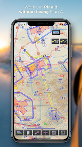
▶ EASY TO READ SMARTMAP
Our new Vector Map is beautiful AND it has brains! See only what really matters, based on the viewpoint and time that you fly. The map displays terrain, obstacles, airspaces inc. activation status, airports, private airstrips, NOTAMs, and weather.
▶ CONNECT WITH THE OUTSIDE WORLD
EasyVFR works with most GPS, FLARM and ADS-B systems over GDL90. No complex setup procedures are involved; get real-time traffic data from your traffic receiver.
▶ ROUTE PLANNING ON THE GO
With its modern and vibrant interface, EasyVFR 4 makes flight planning easier than ever! Tiresome tasks like ATC plan filing, performance / mass & balance calculations are all done automatically and accurately.
▶ WEATHER TO FLY
EasyVFR offers you unprecedented awareness of current and predicted weather around the world. METAR, TAF, GAFOR and SigWX are included as well as advanced weather information like cloud base, wind aloft and density altitude.
▶ GEOREFERENCED CHARTS & PLATES
With the approach plates displayed on the moving map, you feel at home at every airport around the world!
▶ OFFICIAL AVIATION DATA INCLUDED
The EasyVFR 4 membership provides you with updated AeroData for all European countries published in line with the 28-day AIRAC cycle.
Our AeroData includes a continuous feed of the following sources:
√ PocketFMS AeroData
√ AIP data from EUROCONTROL
√ NOTAM data from EUROCONTROL
√ AUP/UUP data from EUROCONTROL
√ Airport Plates & Documents from EUROCONTROL
√ Aviation Weather data from Deutscher Wetterdienst (DWD)
√ TERRAIN data from NASA
√ GEOGRAPHICAL data from EuroGeographics and OpenStreetMap
Leading avionics manufacturers such as Dynon Avionics and MGL Avionics are also using PocketFMS AeroData to provide accurate and detailed information to their users.
EasyVFR 4 flight navigation 使用排名
基於 Similarweb 的算法,根據過去 28 天的安裝數和活躍用戶數進行計算。
所有類別 在
美國--
地圖與導航 在
美國--
5月 3, 2026