4月3日 的 Wales Coast Explorer 應用程式分析
Wales Coast Explorer
- Tinint
- Google Play 商店
- 免費版
- 教育
Become a Wales Coast Explorer, with the coastline in your pocket.
The Wales Coast Explorer | Crwydro Arfordir Cymru is your go-to FREE app for exploring the whole Welsh coastline – from estuary to ocean, beach to clifftop.
Whether visiting or living locally, use the Wales Coast Explorer to plan your trip, enjoy the wildlife and landscapes and learn how to protect them.
Features:
Marine Codes of Conduct
Equip yourself with the knowledge you need to enjoy the coastline responsibly – including exclusion zone maps, voluntary codes of conduct, and push notifications for sensitive habitats
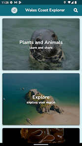
Wildlife Identification
Your handy pocket guide to identifying the wildlife you are likely to see while out and about on the Welsh coast, estuaries and seas
Wildlife Facts
Learn about the amazing wildlife around the coastline of Wales – from seabirds to seals, dolphins to anemones, creepy crawlies to plants!
Report a Sighting
Share photos and locations of your wildlife sightings, and contribute towards the body of knowledge collected by your local Biodiversity Information Centre
Maritime Archaeology
NEW for 2022! Use our handy map to discover archaeological sites along the Welsh coast – including shipwrecks, promontory forts, ancient forests and other fascinating sites.
Report an Archaeological site!
As tides wash out and sands shift, old sites of interest can be exposed. Archaeologists at the Royal Commission on Ancient and Historical Monuments of Wales https://rcahmw.gov.uk/ are looking for YOUR help to record the condition of these sites. Submit your photos and sightings via the App!
Invasive Species
Spotted something that shouldn’t be there? Get to know the Invasive Non Native Species (INNS) for your area and support your local Biodiversity Information Centre by reporting your sighting through the App
Fully bilingual
The Wales Coast Explorer | Crwydro Arfordir Cymru is a fully bilingual App – just set your preference to English or Welsh within the App
Tide Tables
Never be caught out by the tide – use the accurate tide tables on the App to plan your trip (currently only available in Pembrokeshire)
Geology and Industry
Find sites showcasing the geology and industry of your area (currently only available in Pembrokeshire)
Restriction Alerts
By enabling background location mode, receive push notifications to agreed access restrictions that have been drawn up by conservation organisations and coastal users. These have been agreed to preserve and protect the marine wildlife, including the following access restriction zones:
• Seabirds nesting
• Seal area
• Priority to wildlife
• Slow: Minimum speed
• Harbour
• Ministry of Defence area
• Extreme Caution: Porpoise area
Plan ahead – Keep your distance – Reduce speed and sound
Wildlife Safari
• Explore regions
• View walking routes
• Lean and identify 'The Big 5' species
• 360 VR images on current and 'Changed Landscapes'
Note:
Continued use of GPS can decrease the battery life of your device.
The Wales Coast Explorer | Crwydro Arfordir Cymru is a project led by Pembrokeshire Coastal Forum and delivered jointly by Marine SACs in Wales and NRW, funded by Welsh Government via Wales Marine Protected Areas.
Maritime Archaeology information funded by and developed in collaboration with the Royal Commission on Ancient and Historical Monuments of Wales (RCAHMW). https://rcahmw.gov.uk/
Wales Coast Explorer 使用排名
基於 Similarweb 的算法,根據過去 28 天的安裝數和活躍用戶數進行計算。
所有類別 在
美國--
教育 在
美國--
4月 3, 2026