5月2日 的 Drone Scanner (legacy) 應用程式分析
Drone Scanner (legacy)
- Dronetag
- Google Play 商店
- 免費版
- 工具
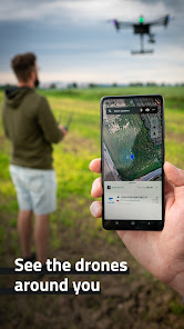
Transform your phone or tablet into a drone scanner and track all the nearby flights over Direct / Broadcast Remote ID standards. Browse real-time data about drones on a detailed map highlighting specific flying space zones. Download Drone Scanner for free and discover what drones fly above your head.
Favourite features:
- Discover more about drones flying nearby in real-time
- Examine detailed information broadcasted by drones via Bluetooth 4, Bluetooth 5, Wi-Fi Beacon, and Wi-Fi NAN
- Browse a detailed map with your location and all nearby aircraft
- Check available data about drones, including real-time height, direction, pilot identification, pilot position, operation description, and location history
- Various flying zones marked and highlighted on the map
- Easy export of collected data
- Continuously updated to reflect the latest EU & US regulations
All these features you find in Drone Scanner – a free app for tracking drones. The app is developed by Dronetag company manufacturing devices for drone remote identification.
How it works
Anyone can quickly identify what drones are flying in the sky nearby. Direct Remote ID is a feature that transmits live flight data via Bluetooth or Wi-Fi to the surrounding area. Drone manufacturers use various technologies to build an identification feature in new drones. Pilots of older drones are using add-on devices, enabling them to become digitally visible. With hardware on your smartphone, Drone Scanner can receive and read broadcasted data.
Drone Scanner (legacy) 使用排名
基於 Similarweb 的算法,根據過去 28 天的安裝數和活躍用戶數進行計算。
所有類別 在
美國--
工具 在
美國#3,852
用戶興趣和熱門類別
Drone Scanner (legacy)用戶使用的熱門類別和應用程式
5月 2, 2026