4月24日的SailFreeGPS应用程序分析
SailFreeGPS
- FredB
- Google Play 商店
- 免费
- 体育
Hello,
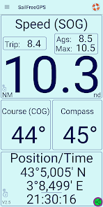
✓ SailFreeGPS displays current location, course (COG), speed (SOG), max speed, Trip distance, speed average and magnetic compass.
✓ SailFreeGPS displays COG and SOG history (6h) to help you to see trim effect on your sails.
✓ SailFreeGPS filters GPS information for more accuracy (average of an amount of last measures you can set).
✓ SailFreeGPS can share your position, COG, SOG to your friends.
✓ SailFreeGPS helps you during Man OverBoard maneuver (MOB). It stores the location and lead you to it.
✓ SailFreeGPS displays your track on google map (48h).
✓ SailFreeGPS helps you during Regatta with its countdown timer and its departure line
✓ You can store up to 8 waypoints and activate a GOTO function with ETA (Estimated Time to Arrival computation)
✓ You can save/load track to/from GPX/KML file
✓ You can calculate distance and heading
✓ You can use it on every boat, motor or sail boat.
✓ You can now activate an anchor alarm or a course alarm.
I am an amateur sailor who has decided to create this app after a Transatlantic cruise.
I add periodically functionalities to this app when I have some spare time.
Do not forget to calibrate your compass for better results.
Please send me an email for any question or problem : contact@sailfreegps.com
Encourage me to continue by subscribing to premium version.
List of features of Premium Version
Premium version DOES NOT CONTAIN ADS.
GPS INFO Tab:
✓ Double click on SPEED will reset trip, max and ags speed
✓ Long click on COURSE to display compass
✓ Double click on coordinates to display/hide position
Graph Tab:
✓ Double click COG graph to switch to full screen mode
MOB Tab:
✓ Displays of relative bearing of the MOB
✓ Displays of tack angles
✓ Double click graph to switch to full screen mode
Waypoint Tab:
✓ Up to 200 Waypoints
✓ Displays of relative bearing of Waypoint
✓ Displays of tack angles
✓ Double click graph to switch to full screen mode
Map Tab:
✓ Displays of SOG and COG (speed & course)
✓ Your track segments are displayed according to your speed
Anchor alarm:
✓ Anchor area can be a polygon and you can adjust its shape
Regatta Tab:
✓ "Gun Button" allows to round seconds to nearest minute
Ex: 4:03 => 4:00 or 3:58 => 4:00
✓ Enter exact start time up to the second
✓ Displays of time to kill/save continuing the same way (speed and course)
✓ Displays of ideal speed to cross the line at 0:00 on the same course!!!
Settings Tab:
✓ Displays reverse color (white on black back)
✓ You can select Hybrid map
✓ Select on which duration is calculated the speed scale of your track: last 5min, 15 min or all the track
✓ Select your tack angle value. It will be displayed on MOB and WAYPOINT tabs
Exit:
✓ Ask to save the track before Exit
Note: SailFreeGPS uses a foreground service to get your location
SailFreeGPS 使用排名
使用率排名基于 Similarweb 的算法,该算法会计算 28 天内的当前安装量和活跃用户数。
所有品类在
美国--
体育在
美国--
四月 24, 2026