2月22日的AFIS Wildfire Map应用程序分析
AFIS Wildfire Map
- CSIR
- Google Play 商店
- 免费
- 天气
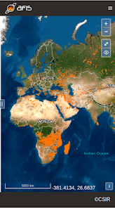
Get the latest updates on wildfire locations with the CSIR's AFIS Wildfire Map app that puts vital wildfire information at your fingertips. AFIS gives you access to fires detected globally by NASA's Terra and Aqua satellites as well as the SNPP and NOAA-20 satellites.
This app provides native access to the AFIS Viewer that is available online at https://viewer.afis.co.za/
This app replaces the previous AFIS app that was no longer maintainable. New features will be added over time.
Visit the South African Council for Scientific and Industrial Research (CSIR) website for more information about the organization behind AFIS: https://www.csir.co.za
AFIS Wildfire Map 使用排名
使用率排名基于 Similarweb 的算法,该算法会计算 28 天内的当前安装量和活跃用户数。
所有品类在
德国--
天气在
德国--
二月 22, 2026