You’ve hit your search limit
Start your free trial to keep exploring full traffic and performance insights.
Get StartedAnálisis de la app Swiss3D para 21 de abril
Swiss3D
- Louis-Joseph Mayoraz
- App Store de Apple
- Gratis
- Viajes
*** Appreciated by "Le Nouvelliste", "mac4ever.com", "iPhone-blog.ch" and perhaps you!
*** "Best of Swiss Apps Award 2017" nominated
- At which altitude and distance is the cliff over there?
- What is the name of this small town below?
- How is called the peak we are seeing?
- What is the altitude of the Grimsel pass?
- Which mountain is the highest of the region?
- Is there a camping or a mountain refuge nearby?
- What is the name of this glacier or that lake?
- Is it Jupiter right over this peak?
- The region on this hill has a lot of sun?
- How much walk time is needed to reach that crest, is it steep?
- Is there any message posted by somebody in this area?
- I am asking myself where is the Mattherhorn from here?
- What view do we have from the top of this mountain?
- Is it full moon and where is the moon?
- Is this whole valley over 1000m?
...
It is a question list sample that can be answered with Swiss3D!
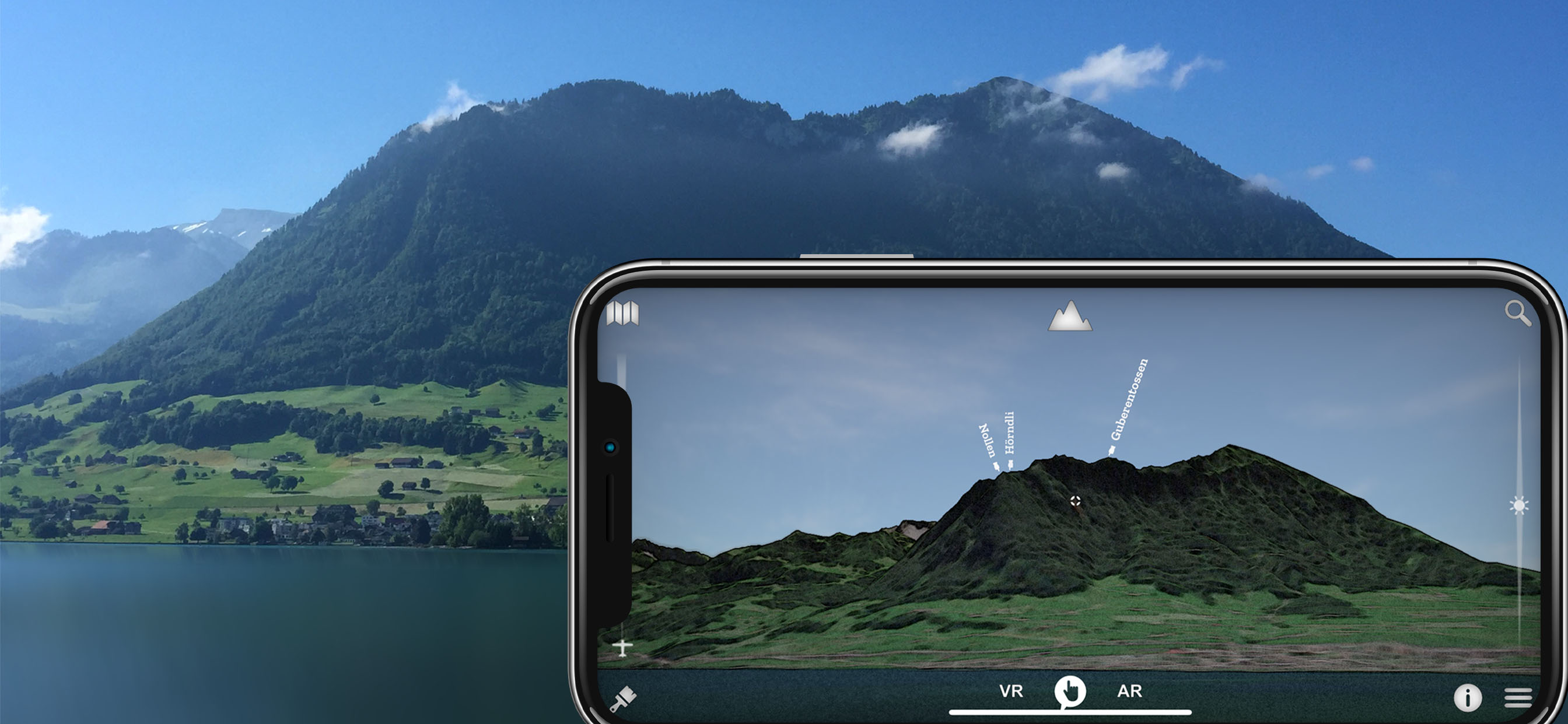
Swiss 3D is a, fully offline, precise, real time, virtual 3D map of Switzerland.
It reconstructs your surrounding landscape with accuracy and displays all peaks, towns, cities, places, lakes, passes, glaciers, mountain huts, ...
It also rebuild the current time sky and shows all brightest stars, solar system planets and all constellations.
The app contains an VR and AR mode that enable you to see the environment as seen through binoculars.
You can also share your current favorite position to everybody.
Reading a map has never been that fun and easy!
Features:
▫ no internet connection required
▫ virtual and augmented reality (ARKit) or manual mode
▫ accurate Swisstopo data
▫ 54000 places, 15000 peaks, 9000 stars, pass, lakes, mountain huts, ...
▫ landsat satellite imagery
▫ summer and winter
▫ search function
▫ dynamic aerial view
▫ easy controls
▫ map
▫ flight simulator
▫ share and comment your favorite location
▫ target information: distance, altitude, slope, sun time, walk time...
▫ only on iOS
▫ made in Switzerland for Switzerland
-> iPhone 6s (A9) and more required for the AR!
Source: Office fédéral de topographie / geonames
Satellite Image: Modified Copernicus Sentinel data [2019] swisstopo, NPOC
Elevation Data: ViewFinderPanoramas
Stars: Bright Star/Hipparcos catalogue, Jean Meeus
Constellations: Stellarium / Johan Meuris pictures
Cockpit: Vertical Reality Simulations
Clasificación de tiendas
El Store Rank se basa en múltiples parámetros establecidos por Google y Apple.
Todas las categorías en
Estados Unidos--
Viajes en
Estados Unidos--
Principales competidores & aplicaciones alternativas
Aplicaciones con una alta probabilidad de ser utilizadas por los mismos usuarios, desde la misma tienda.
Swiss Pro Map
SwitzerlandMobility
SAC – Swiss Alpine Club
swisstopo
abril 21, 2026