You’ve hit your search limit
Start your free trial to keep exploring full traffic and performance insights.
Get StartedAnálisis de la app Public transport map Warsaw para 3 de mayo
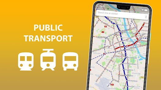
Public transport map Warsaw
- Sklr
- Google Play Store
- Gratis
- Automoción y vehículos
The entire Warsaw's transport infrastructure of in one app. Metro lines, trams and buses routes, transfer stations - all of those you will find inside.
Search by station name or route number, saving chosen routes and geo-positioning are available in the basic version.
Why do this app is should be tried?
1) On the screen of your device you will see the whole Warsaw's public transport scheme, and the more scale is choosen the more details are given.
2) The map of Warsaw shows not only metro lines, but tram and bus routes as well. Stations of possible metro-tram-bus transfers are grouped.
3) The search by station name will help you to find it on the map and select the proper transport. Search by route number allows you to quickly determine whether it suitable or not.
4) By allowing the application to access the location and mark it on the map, you will see stations nearby. So you won't ever get lost and without any help you will be able to get anywhere in the city.
5) The routes you planned in advance, can be saved in the list and you may use them again at any time.
In an extended version, the app allow you:
6) To use all of the above in offline mode without wasting time searching for the wifi reception.
7) To check a short schedule of public transport routes if it is needed.
8) To know not just where the station is, but where the stops of all routes passing through are located as well.
Confident use of all types of public transport is the key to the most comfortable visiting Warsaw.
Clasificación del uso de Public transport map Warsaw
El rango de uso se basa en el algoritmo de Similarweb que calcula las instalaciones actuales y los usuarios activos durante un periodo de 28 días.
Todas las categorías en
Estados Unidos--
Automoción y vehículos en
Estados Unidos--
Principales competidores & aplicaciones alternativas
Aplicaciones con una alta probabilidad de ser utilizadas por los mismos usuarios, desde la misma tienda.
Rome2Rio: Trip Planner
PID Litacka
Eurail/Interrail Rail Planner
mayo 3, 2026