You’ve hit your search limit
Start your free trial to keep exploring full traffic and performance insights.
Get StartedAnalyse de l'application Air Navigation - VFR & IFR pour le 19 février
Air Navigation - VFR & IFR
- Flygo-Aviation Ltd
- App Store Apple
- Gratuit
- Navigation
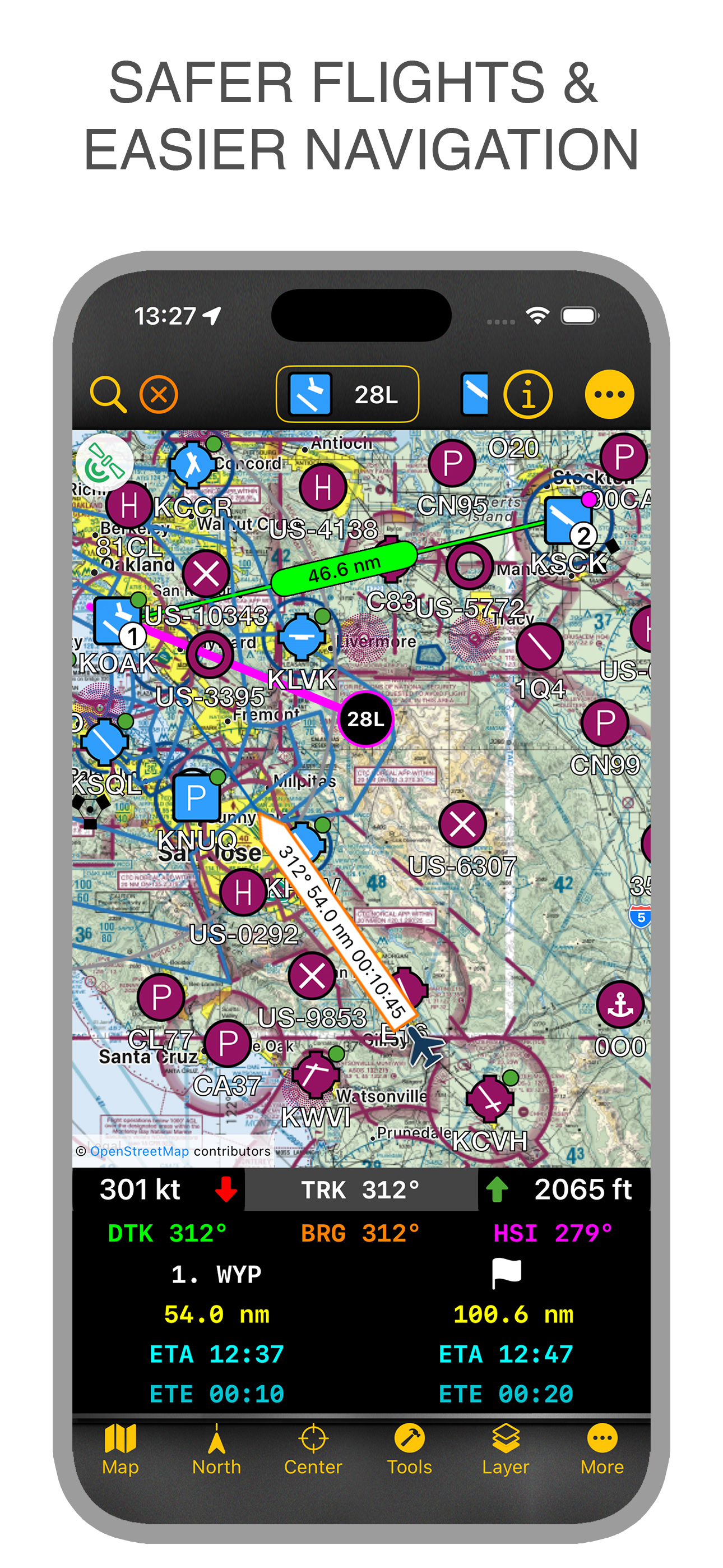
Air Navigation - VFR & IFR is the ultimate flight planning and navigation app for pilots. Plan VFR or IFR flights with worldwide charts, real-time weather (METAR/TAF), NOTAMs, terrain awareness, airport information, and more – all in one easy-to-use app.
Download and try PRO free for 1 month! *
Features:
• Route planning
Create and save routes with 50,000+ airports, navaids, and waypoints.
• Maps and charts, connected to GPS
Navigate with updated sectional and en-route charts in the US and EU **. Customize maps with airports, airspaces, navaids, and weather layers.
• Weather
Access worldwide METAR and TAF reports.
• Offline use
Download maps, charts, and terrain for offline flying.
• Terrain avoidance system ***
Stay aware of dangerous terrain with clear visual alerts.
• EHSI / RMI instruments
Fly procedures with digital navigation instruments.
• Nearby airports
Quickly find alternate airports, their distance, and relative direction.
• Real-time flight information
Heading, track, distance, ETA, ETE, speed, and waypoints.
• iCloud synchronization
Sync your data between multiple devices.
• Airport information
Runways, frequencies, navaids, NOTAMs, and weather data.
• User points
Add custom waypoints by tapping the map or entering coordinates.
• Quick tap mode
Tap any location to view airspace, frequencies, SIGMETs, AIRMETs, and runway data.
• SIGMETs & AIRMETs
Global weather advisories displayed on the map.
• Advanced search
Find airports by name, city, ICAO, or IATA.
• Navigation modes
Switch between magnetic and true north.
• Units
Choose between imperial (US) and metric units.
• Flight history
Review your past routes and flights.
* Subscriptions: BASIC and PRO. Unlimited charts, terrain, and the 1-month trial are included with PRO. BASIC offers a 2-week trial.
** EU sectional charts are available in Belgium, Germany, Finland, the Netherlands, Denmark, Poland, Sweden, Bulgaria, Croatia, Greece, Hungary, Italy, Slovenia, the Czech Republic, Malta, Austria, Romania, Switzerland, and Slovakia. Additional charts are available in South Africa and Namibia. Charts provided by Open Flight Maps.
*** Terrain data available from 60°N to 57°S.
Disclaimer: This is not a certified flight instrument. Pilots must not rely solely on the app for navigation. Always use approved avionics for flight safety.
Manual: https://www.flygo-aviation.com/wp-content/uploads/2021/10/FlyGo-Air-Navigation-Quickstart-Guide.pdf
Terms of use: https://www.flygo-aviation.com/air-navigation-terms-of-use/
Privacy policy: https://www.flygo-aviation.com/air-navigation-privacy-policy/
Classement dans le store
Le classement des stores est basé sur plusieurs paramètres définis par Google et Apple.
Toutes les catégories dans
États-Unis--
Navigation dans
États-Unis--
Principaux concurrents & apps alternatives
Applications ayant une forte probabilité d'être utilisées par les mêmes utilisateurs, à partir du même store.
Air Navigation Pro
Airmate
AeroChart
SkyCharts XC EFB
février 19, 2026