

You’ve hit your search limit
Start your free trial to keep exploring full traffic and performance insights.
Get StartedPeakList análises de aplicativos para 10 de outubro

PeakList
- Alan Reid
- Apple App Store
- Pagos
- Navegação
Peak List keeps the record of every hill you've climbed.
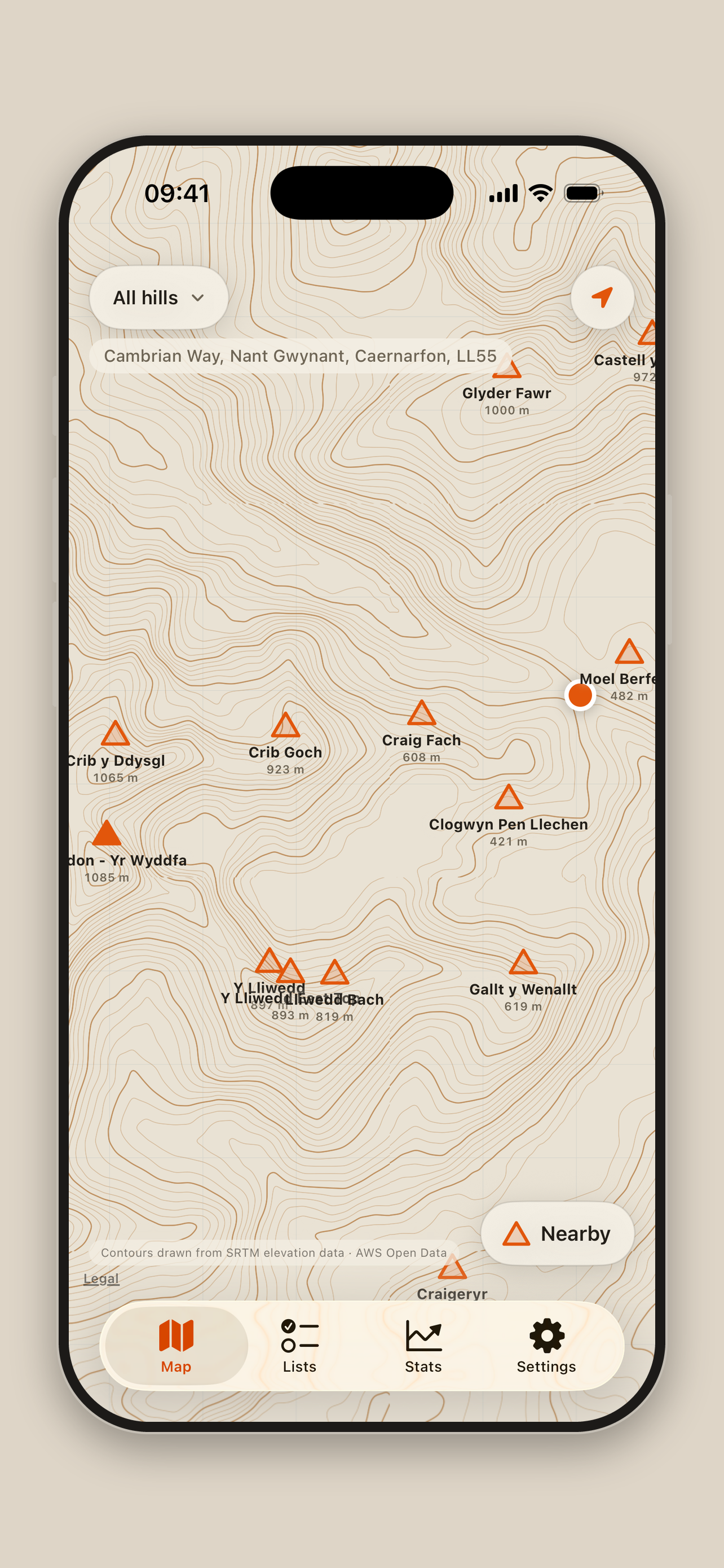
Over 20,000 summits across Britain and Ireland — Munros, Wainwrights, Corbetts, Grahams, Nuttalls, Hewitts, county tops and more — on a map you can actually read.
A MAP DRAWN FOR HILLS
Peak List draws its own map. Rather than borrowing a general-purpose basemap covered in roads and shopping centres, it takes real elevation data and renders the contour lines itself: bistre lines on paper, a kilometre grid, and the shape of the ground with nothing in the way.
Apple Maps is there too, for when you want roads and place names.
Summits you've climbed fill in orange. The ones you haven't sit hollow, waiting.
Tiles are cached as you go, so anywhere you've already looked works with no signal at all.
LOG IT PROPERLY
Tap a summit and log it. Set the date to whenever you actually climbed it — years ago is fine, and most people arrive with a decade of history to enter.
Add the route, the distance, the height climbed, the time it took, what the weather did. Or add none of it. A hill you climbed in 1998 and remember nothing else about still counts.
Got something wrong? Every ascent can be edited or deleted, from the hill's own page or from your full log.
Climb six summits on one round and Peak List knows it was one walk, not six — so the distance is counted once and your totals stay honest.
STATS WORTH LOOKING AT
Summits, days out, height gained. Your climbing rate in metres per hour. Your longest run of months without missing one. Your most-repeated hill.
Your Naismith factor: how your real times compare to the standard planning rule of an hour per 5 km plus an hour per 600 m of ascent. Take the book time for any route and multiply. Genuinely useful before a big day.
CLIMB THE LADDER
Every metre you climb counts toward the next milestone. Yr Wyddfa, then Ben Nevis, then Mont Blanc, Kilimanjaro, Denali, Aconcagua, K2, Everest.
Then it gets silly. Mauna Kea measured from the seabed. Maxwell Montes on Venus. Olympus Mons on Mars, two and a half Everests tall. The Kármán line, where space begins.
Each one has to be climbed in full — no carrying height over from the last.
CHALLENGES
The National Three Peaks, the Yorkshire Three Peaks, the Welsh 3000s, the Snowdon Horseshoe, the Scottish 4000ers and more. Peak List can tell whether you did one properly in a single round, or collected it over three summers. Both count. Only one gets the badge.
YOURS, AND PRIVATE
No account. No sign-up. No advertising, no analytics, no tracking.
Your ascents live on your device and sync through your own iCloud, so they follow you to a new phone. Nobody else can see them, including us.
Metres or feet, kilometres or miles, chosen separately. Light and dark, or follow the phone.
Hill data from the Database of British and Irish Hills. Contours drawn from public elevation data. Works entirely offline once you've looked at somewhere.
Ranking da Loja
A Store Rank é baseado em vários parâmetros definidos pelo Google e Apple.
Todas as categorias em
Estados Unidos--
Navegação em
Estados Unidos--
PeakListoutubro 10, 2026