You’ve hit your search limit
Start your free trial to keep exploring full traffic and performance insights.
Get StartedGeoAce app analytics for January 19
GeoAce
- e.quinox KG
- Apple App Store
- Free
- Business
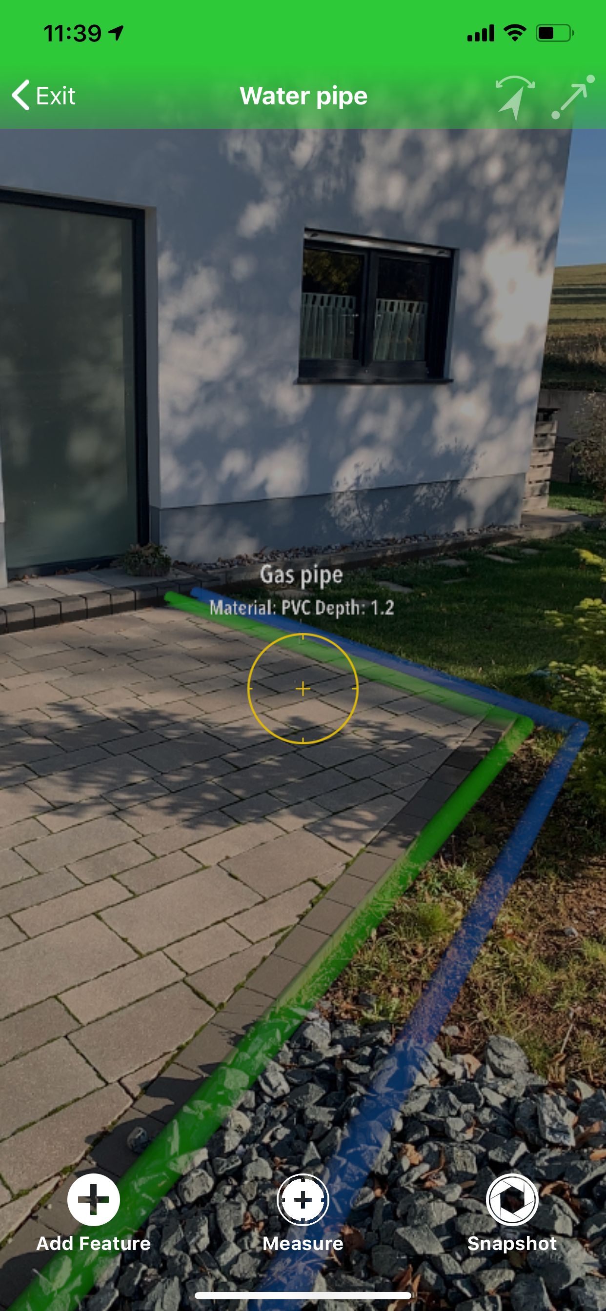
GeoAce is a super-easy-to-use surveying application, for both surveyors and non-surveyors, who want to accurately collect geospatial data or locate (stakeout) such data on-site. GeoAce turns your smartphone or tablet into a precise, centimeter-accurate surveying system, without the need to use GNSS receivers or total stations.
It uses Visual SLAM positioning and Augmented Reality technology to accurately determine the position of your smartphone/tablet in space and collect 3-dimensional data at the same time directly in the video stream. It doesn’t rely on GNSS positioning, so it can be used also indoors, under tree coverage and even in underground mining. You can connect external GNSS receivers to further increase the versatility of the application and accuracy. You can upgrade your GNSS receivers from Leica, Trimble, eSurvey, Stonex, Emlid and others with GeoAce to an Augmented Reality rover working everywhere, even in areas where GNSS usually wont work.
The results are ready to use drawings in PDF and standard CAD & GIS formats. GeoAce doesn’t require a network connection and all processing and exporting is done on the device.
Key Features:
• 2D MapView with more than 245 Overlay Map Layers
• Offline Maps
• 3D Augmented Reality view
• Data collection in 3D Augmented Reality view
• Visual Stakeout (points and polylines)
• Feature and Layer manager
• Apple Watch support
• Import GeoJSON, Esri SHP, DXF, DWG, DGN, GPX, OSM, CSV, KML/KMZ files
• Export GeoJSON, Esri SHP, DXF, DWG, DGN, customizable CSV with QA report, Penmap, KML/KMZ
• Georeference a survey by using WMS, WFS, imported CAD or GNSS files
• Survey sketch PDF export with linear and chain & offset dimensions
• Assign tasks to specific users
• Sync data between multiple devices
• Photo documentation of results
• World-wide coordinate system and geoid support
• Connection to external GNSS receivers
• Quality (RMS) and status information
Subscription types:
1. Free Subscription functionality:
• Import: all formats
• Overlay imported data on top of Apple maps
• Precise GNSS surveying and CSV export
• Free 7 days trial of all “Survey" subscription features
Paid subscription:
2. "View" Subscription, all features of the Free subscription, plus
• Visual stakeout with external GNSS in Augmented Reality
• Apple watch support
• WMS, TMS and WFS, offline maps
• Export: PDF, GeoJSON, Esri, DXF
• Sync between devices
3. "GIS" Subscription, all features of the "View" subscription, plus
• Visual SLAM data collection in Augmented Reality
• Georeferencing
4. "Survey" Subscription, all features of the "GIS" subscription, plus
• GNSS data collection in Augmented Reality with eBubble and tilt compensation
• Export: DWG, DGN
• Teamleader reporting
Purchase of a GeoAce subscription allows you to run the GeoAce App on all supported platforms, with your tasks and projects being automatically synchronized between your devices. Subscription payments will be charged to your iTunes Account at confirmation of purchase and will automatically renew unless you cancel your subscription or turn off auto-renewal at least 24-hours prior to the end of the current subscription period. A cancelled subscription remains active until the end of the current period, at which time your account reverts to the “Free" subscription functionality.
Customers selecting the Free Trial will enjoy “Survey" subscription features for a period of 7 days, after which they can elect to purchase a paid subscription. In the absence of a purchase, their account will revert to “Free" subscription functionality.
For further information:
• GeoAce Privacy Policy: https://its-geo.eu/Privacy.html
• GeoAce Terms of Use: https://its-geo.eu/terms-of-service.html
Store Rank
The Store Rank is based on multiple parameters set by Google and Apple.
All Categories in
United States--
Business in
United States--
Top Competitors & Alternative Apps
Apps with a high probability of being used by the same users, from the same store.
vSite AR
Vaira
SitePlan
vSite Scan
January 19, 2026