You’ve hit your search limit
Start your free trial to keep exploring full traffic and performance insights.
Get StartedDroneDeploy Flight App analisi dell'app per 11 gennaio
DroneDeploy Flight App
- Infatics, Inc.
- App Store di Apple
- Gratis
- Foto e video
DroneDeploy is the leading flight app for drones with millions of missions flown by over 130,000 pilots.
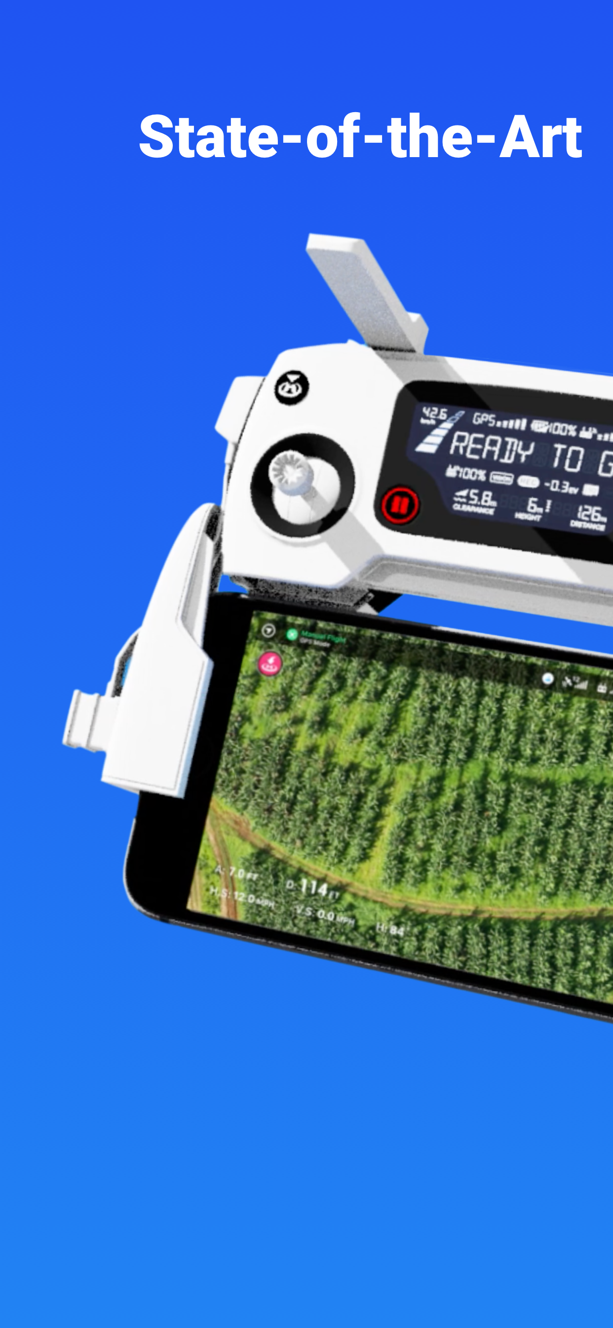
DroneDeploy is the leading cloud software platform for commercial drones, making the power of aerial data accessible and productive for everyone. The free DroneDeploy app provides easy automated flight and data capture, and enables you to create, explore and share high-quality interactive maps, orthomosaics and 3D models directly from your mobile device.
Fly your DJI drone autonomously with just two taps on your iOS device. Quickly process your imagery with DroneDeploy to generate accurate, high-resolution maps and 3D models. Analyze, annotate and share your maps with others directly from within the app. Extend your capabilities and take your analysis to the next level with AI reporting and over 80 best-in-class apps available for install within DroneDeploy’s App Market.
DroneDeploy is the ultimate app for a wide range of high-accuracy aerial imaging and mapping applications in construction, solar, agriculture, surveying, mining, insurance, inspection and more. DroneDeploy has empowered users to map and analyze over 30 million acres in more than 160 countries.
DRONE SUPPORT
• Mavic 2 Pro / Zoom / Enterprise / Dual (thermal)
• Mavic Air 2
• DJI Air 2S
• Phantom 4 Pro V1 / V2
• Phantom 4
• Inspire 2
• Matrice 200 / 210 / 210 RTK V1 / V2
• Matrice 300 RTK
Not compatible with the following hardware:
• DJI Mavic Mini series
HIGHLIGHTS
• Easily plan and schedule repeatable flights
• Fly and capture massive areas
• Disable auto-flight with a single tap
• Includes a full featured manual flight mode
• Film professional quality video hands-free
• Create automated spherical panoramas
• Record all your flight logs in one place
• Measure elevation, distance, volumes, surface area and roof geometry (roof reports)
• Quickly create survey-grade maps and models with ground control points
• Collaborate with teams through shared maps, annotations and comments
• Wirelessly upload images from the drone
• Export data in the format you need - JPG, Geotiff, OBJ, XYZ, LAS
• Explore orthomosaic, NDVI, VARI, digital elevation maps and 3D models
- - -
Find out more at www.dronedeploy.com
Please join us in improving and discussing the app at http://forum.dronedeploy.com
Classifica degli store
La classifica del store si basa su diversi parametri stabiliti da Google e Apple.
Tutte le categorie in
Brasile--
Foto e video in
Brasile--
Principali concorrenti e app alternative
App con un'alta probabilità di essere utilizzate dagli stessi utenti, provenienti dallo stesso store.
Go Fly for DJI Drones
Map Pilot Pro
Fly Go 4: Drone Mobile Deploy
DJI Go4
gennaio 11, 2026