BLM Public Lands Map Guide USA analisi dell'app per 5 dicembre
BLM Public Lands Map Guide USA
- GeoPOI LLC
- Google Play Store
- A pagamento
- Mappe e navigazione
The United States of America is a vast land full of lush forests, stunning deserts, indescribable landscapes, and fascinating history. You may already know some of the iconic landmarks and wildernesses that the US has to offer, but did you know that there are millions of acres of public Bureau of Land Management property in the Western US? This app is your guide to discovering the unspeakable beauty and recreational potential that is contained within these fabled domains!
Whether you are a seasoned forest wanderer or are just wanting to learn a little more about the amazing places surrounding your home turf, this app is for you! The data is up to date as of Summer of 2024 and contains over 52,000 recreational points and other features on BLM land. These points are symbolized with several color-coded icons that differentiate between the . Categories include Access Points, Boating, Campgrounds, POIs, Vistas, Bathrooms, Parking Lots, Recreational Areas, and much more! The app even distinguishes property boundaries and includes some hiking trails and roads.
We listened to your feedback and have implemented a number of improvements and features. New in the latest update is a custom My Points tool that allows you to create your own points with unique colors and icons, and even export these points. What other things would you like to see in a future update?
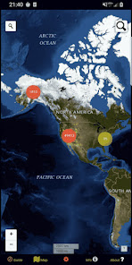
Once using the app, there are five screens. The Guide screen will provide data legends as well as helpful tips for optimizing your navigational experience. On the Info screen, you will find a number of spatial links to the different BLM properties. This is a great way to quickly locate specific places and discover new places to explore! The About screen provides links to all of the open-source resources used in the app and gives a little information about the developer GeoPOI. The Map Settings screen is where you can change between one of four different basemaps, download offline imagery, turn on geolocation, and toggle specific point categories. Finally, the Map screen is where it all comes together!
On the Map screen, there are a series of circle clusters at distant zooms that indicate how many points are within a given cluster. As you tap the clusters to zoom in, individual points and icons become visible, along with trails, roads, and boundaries. These features can be clicked on to reveal the name, location, and other useful information. The map screen also has two search tools - the left one can be used to look up addresses and towns, while the right one will allow you to query the names of the features in the database.
There is such a wealth of beauty out there waiting to be discovered. Never before has it been this easy to navigate our public lands as you travel, no matter where in the United States you are or what kinds of places you are interested in visiting. It's time to experience the rich natural and cultural tapestry of our nation and pay homage to the places that make our country the great land that it is. Come navigate the US BLM lands with GeoPOI today!
NOTE: GeoPOI LLC is not associated with the Bureau of Land Management or the US Government. We include official data from these sources in our apps for your convenience, but are in independent entity.
Point data derived from:
https://catalog.data.gov/dataset/blm-natl-recreation-site-points
Facility information is derived from:
https://gis.blm.gov/arcgis/rest/services/recreation/
Boundary data is from:
https://www.usgs.gov/programs/gap-analysis-project/science/pad-us-data-download
Classifica degli store
La classifica del store si basa su diversi parametri stabiliti da Google e Apple.
Tutte le categorie in
Stati Uniti--
Mappe e navigazione in
Stati Uniti#4
Interessi degli utenti e categorie principali
Le categorie principali e le app utilizzate dagli utenti di BLM Public Lands Map Guide USA
Categorie principali
Affinità
Le migliori app all'interno della categoria
27%
18%
17%
14%
Principali concorrenti e app alternative
App con un'alta probabilità di essere utilizzate dagli stessi utenti, provenienti dallo stesso store.
Harvest Hosts - RV Camping
Road to Hana Maui Audio Tours
Recreation.gov
Regrid Property App
5icembre d, 2025