12月4日 的 ok2fly 應用程式分析
ok2fly
- AvSoft Australia Pty Ltd
- Google Play 商店
- 免費版
- 地圖與導航
Whether you are a recreational drone pilot or a fully-fledged professional drone pilot, ok2fly™ is the drone safety tool you need for you next drone mission. ok2fly boasts the following functions:
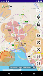
1. Detailed visualization of runway splays and airport envelopes
- Splays and envelopes are clearly displayed so the pilot can identify boundaries between airspace inside and outside of the operational areas.
2. Extended radius review of the drone flight area
- ok2fly will survey not only the location you will be flying from, but the immediate area around you
- You can configure the visual flight radius to suit your planned flight operations
3. Street level vector map of the whole of Australia
- The ok2fly vector map details standard street map information as well relevant aviation details such as obstacles, low level aviation activities and recreational sites
- You overlay further information using the Layers option*.
4. Fully implements the CASA RPAS Rules
- ok2fly is fully compliant with the CASA RPAS Safety Rules and fully integrated with the CASA RPAS Platform.
- ok2fly was the first safety app to go live as part of the CASA / Airservices Australia Airspace Authorisation trial.
5. Detailed reporting beyond the basic “yes I can” or “no I can’t fly”
- To get a more thorough understanding of the operational environment ok2fly will analyses the airspace surrounding your location
- ok2fly will provide a location report detailing all known landmarks detected in the operational airspace
6. Configure to match your drone pilot qualifications
- ok2lfy supports the 3 drone pilot types defined by the CASA safety rules, namely Recreational, Commercial Excluded* and ReOC*
- From the settings function, set the pilot type to match your qualifications*
7. Map adjusts to reflect activity at proposed flight time
- If you are flying in 1-hour, 1-day or 1-week’s time, the operational environment may be different.
- When you set the proposed time of your flight, ok2fly will reconfigure all time-based objects to reflect their status at that time.
8. Real-time activation and visualization of Restricted and Danger areas
- ok2fly maintains an activity schedule for Restricted and Danger Area airspace and uses the schedule information to depict airspace as active or inactive.
- When set to current time mode airspace activates and deactivates automatically as the time-of-day progresses
- If you select a specific flight time, ok2fly will set the state of all airspace based on that time
9. Automatic visualisation of NOTAM activities effecting drone operations
- Activities include planned drone flights, from surface to above activities such as Low Jet Routes and TRA
- Other activities such as Rocket Launches and Fireworks displays may also be included
- 4D objects are used to represent the activity and included in flight queries where they intersect geographically, vertically, and temporally
10. Continuously updated NAIPS NOTAM information
- NOTAMS for Restricted and Danger airspace are available for inspection by the drone pilot*
11. Links to supplemental decision-making information
- The Information function of ok2fly contains a selection of relevant links for drone pilots
- Links to CASA, Airservices, BOM and AvSoft Australia are included
12. Radio frequency data for FIA and airport communications
- Access supplemental airfield information for flight planning and mission communication purposes*
13. Additional aviation data to aid drone flight planning
- In addition to the standard aviation data, ok2fly maintains information on other artefacts that aid with situational awareness
- This can include Schools, Local Parks, Beaches, Embassies, Prisons, Major Roads and Rail Lines.
14. AvSoft Australia is a CASA Part 175 approved data provider
* Requires a subscription.
The term ok2fly™ is a trademark of AvSoft Australia Pty Ltd.
ok2fly 使用排名
基於 Similarweb 的算法,根據過去 28 天的安裝數和活躍用戶數進行計算。
所有類別 在
美國--
地圖與導航 在
美國--
12月 4, 2025