12月9日的CALINT应用程序分析
CALINT
- moegi Inc
- Apple 应用商店
- 免费
- 公共事业
Do you get thrilled to get on a fast-moving bullet train or airplane?
Don’t you think it will be more exiting if you can check where you are and how fast you are moving at the same time while you are on it?
Do you enjoy imaging your destination and just feeling you are approaching it?
The recorded location information data can be uploaded and visualized on the web application "CALINT MAP".
Then, CALINT is the right app for you!
CALINT is a video camera app to take videos with a location map.
You can record your fun memories of your travel with a location map and other information all together on one screen.
CALINT allows you to save your data not just in video format, also in other specific formats so that you can reflect your data to mapping services to check your entire travel tracks on a map.does not only record a video, but also It’s not just a video data. You can also save it as text data.
【CALINT suggestion 1】
Have you ever wished… you can check the current location and traveling speed at the same time?
And take a video of what’s you are seeing all together?
CALINT makes it possible.
You can use CALINT on any types of transportation, such as trains, cars, or airplanes, as long as you have a GPS access. You can also use CALINT while you are walking.
CALINT can be used as a recorder for unmanned vehicle by installing your smartphone on an RC vehicle or drone.
【CALINT suggestion 2】
Have you ever wished… you can perform operation and maintenance without any capital investment?
You can use your smartphone as a dash cam with CALINT to record your travel information with video and GPS data instead of purchasing a dash cam.
【Easy operation!】
It’s easy to use CALINT.
CALINT starts to locate where you are on a map and calculate your traveling speed immediately just by opening it. It is fun just looking at it.
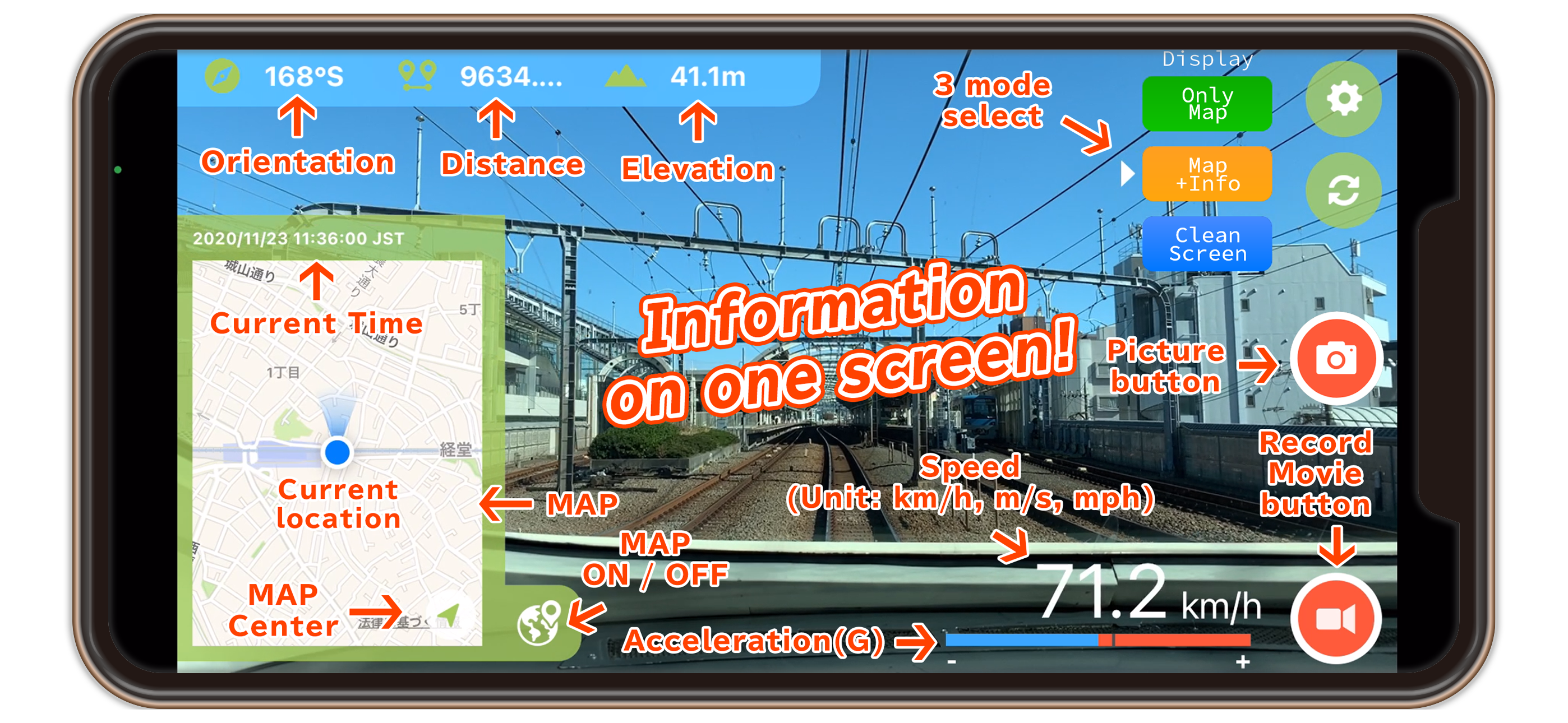
Just tap a red record icon to start recording, then CALINT starts recording your location, traveling speed, altitude, and distance travelled. It also calculates which direction the camera is facing so you can use it as a dash cam, too.
CALINT also has a selfie mode. You can take a video of yourself and your location at the same time.
What you do with CALINT is totally up to you!
CALINT stands for CAmera, Log, Image, Note, and Time.
We call it a “plot mapping video app”.
you can easily take a video and save it as mapping data.
【What kind of information CALINT can record?】
Video data (mp4 format)
Image data (with out/selfie cameras)
Camera direction
Distance travelled (while recording)
Altitude
Current location (on a map)
Speed (km/h, m/s, mph)
Acceleration (+/- G)
Current time
Record duration
【Share your video】
Share your video on social media with #calint
CALINT official Twitter: @calintApp
【Note】
* Monthly subscription (150 yen/month) allow you to hide advertisement.
* Monthly subscription will be renewed automatically, but you can always cancel it from “Setting”.
* To let CALINT function properly, turn ON your network connection (mobile connection or wi-fi) and GPS.
* You may not be able to take a video with Bluetooth connection.
* Make sure your smartphone has enough battery.
* When battery is low, you can still turn on the app, but not use the record function.
CALINT Privacy Policy URL
https://moegi.jp/privacy_policy_en.html
Terms of Service
https://moegi.jp/calint/terms_of_service_en.html
商店排名
商店排名基于 Google 和 Apple 设置的多个参数。
所有品类在
美国--
公共事业在
美国--
十二月 9, 2025