1月9日的3D Mappa - GIS & Topo Analysis应用程序分析
3D Mappa - GIS & Topo Analysis
- Andres Narvaez
- Apple 应用商店
- 免费
- 导航
3D Mappa revolutionizes GIS on mobile. Our app puts powerful terrain analysis tools in the palm of your hand, making complex tasks effortless. Instantly visualize elevation, slope, contours, and more. Simplify workflows with intuitive features designed for speed and efficiency. Export data in seconds to industry-standard formats like DXF, SHP, CSV, OBJ, glTIF, and STL, ensuring compatibility with AutoCAD, and GIS software. Say goodbye to cumbersome processes and hello to streamlined GIS on mobile.
KEY FEATURES:
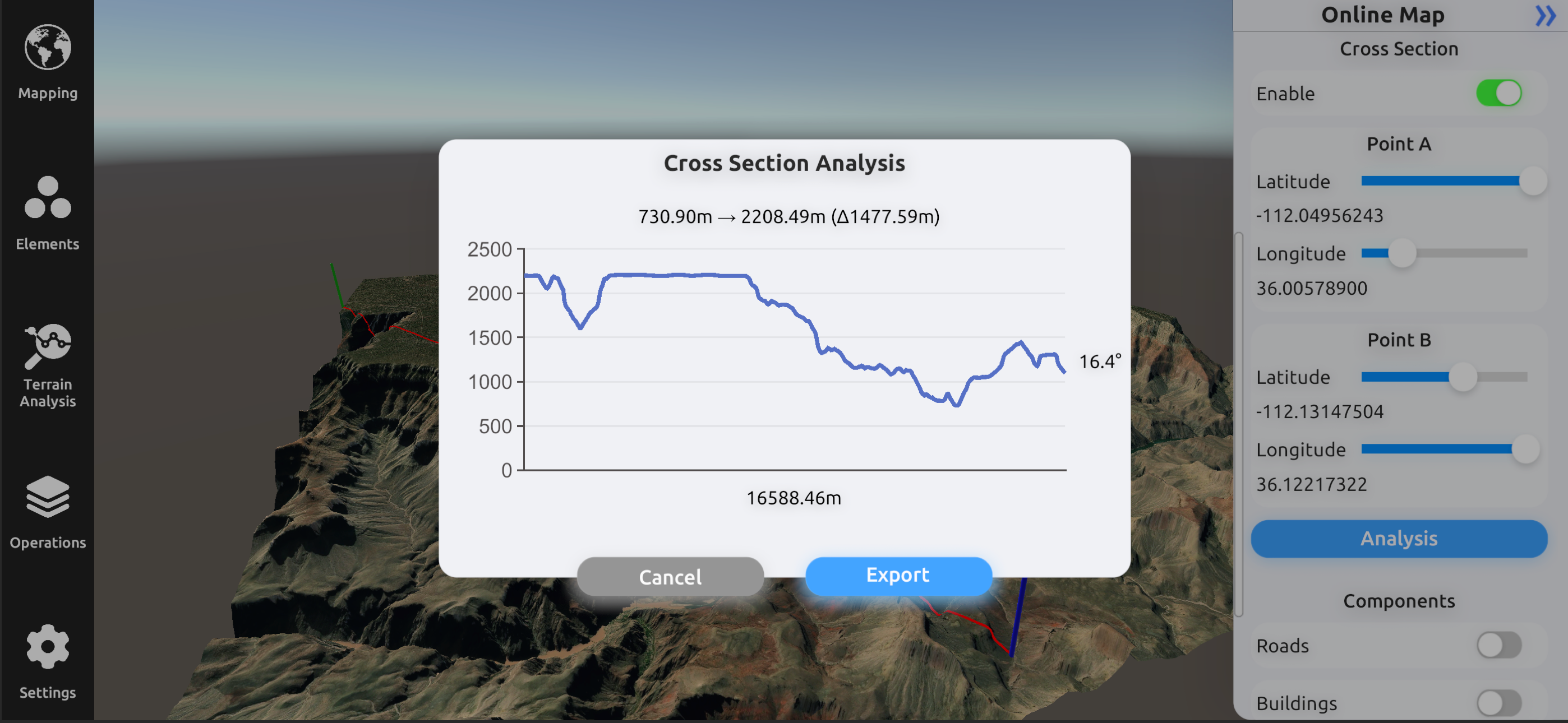
- Cross Section: Visualize changes in elevation and other terrain characteristics in a 2D plot.
- Contour Map: Represents lines connecting points of equal elevation on the terrain.
- Elevation Map: Depicts the elevation or height values of the terrain as a grayscale or color image.
- Slope Map: Represents the steepness or incline of the terrain at each location.
- Aspect Map: Shows the compass direction that a slope faces.
- Normal Map: Shows the surface orientation and angle of each point.
- Flow Map: Illustrates the direction of water flow or drainage patterns across the landscape.
- Landform Map: Depicts the different types of landforms or land features present in the area.
- Curvature Map: Indicates the amount and direction of curvature of the terrain.
- Residual Map: Highlights variations or deviations from a baseline, often used in geological analysis.
ADDITIONAL FUNCTIONALITIES:
- Digital Elevation Models from Data Servers: Create digital elevation models (DEMs) directly from data servers like Google Maps and Mapbox. This functionality allows you to seamlessly integrate high-resolution elevation data from popular map services into your projects, enhancing your analysis with up-to-date and accurate terrain information.
- Import Custom XYZ Files: Import your own XYZ files to create digital elevation models using Delaunay triangulation. This feature allows you to bring your own data into the app, providing flexibility and precision in modeling terrain. The Delaunay triangulation method ensures that your elevation models are accurate and well-formed, making it easier to analyze and visualize complex landscapes.
UPCOMING FEATURES:
- Import LiDAR Files: Display LiDAR data in 2D and 3D for geospatial analysis. This feature will allow you to represent high-precision data obtained by LiDAR technology, providing a detailed view of the terrain and its vegetation.
- Add Objects: Insert custom elements into a map to adjust its scale, position, or other properties. This functionality will facilitate the customization and enhancement of your maps with specific objects according to your needs.
- Buffer: Create buffer zones around points, lines, or areas for spatial analysis. This tool will be useful for evaluating impacts and conducting proximity studies.
- Clipping and Intersect Tools: Perform clipping and intersection operations on your maps to analyze and manipulate spatial data precisely. These tools will allow you to extract and combine specific areas of interest.
- Flood Simulation: Simulate flood scenarios to assess risks and plan mitigation measures. This feature will enable the prediction of water behavior under various conditions and help plan appropriate responses.
Terms of Use: https://www.apple.com/legal/internet-services/itunes/dev/stdeula/
商店排名
商店排名基于 Google 和 Apple 设置的多个参数。
所有品类在
美国--
导航在
美国--
一月 9, 2026