You’ve hit your search limit
Start your free trial to keep exploring full traffic and performance insights.
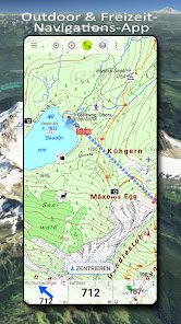
Get StartedAnalyse de l'application German Topo Maps pour le 3 mai
German Topo Maps
- ATLOGIS Geoinformatics GmbH & Co. KG
- Google Play Store
- Gratuit
- Cartes & Navigation
Offline GPS Navigation with Topographic Maps and Aerial Imagery for Germany
Powerful and easy-to-use outdoor navigation app with high-resolution topographic maps, official aerial imagery, and advanced navigation tools – ideal for hiking, cycling, and all outdoor activities.
High-Resolution Maps for Germany
Access the best available map sources:
• Basemap LiDAR Hillshade: Based on official ATKIS Base-DLM data from the Federal Agency for Cartography and Geodesy (BKG), enhanced with fine hillshading
• DTK Topo LiDAR Hillshade: Official topographic maps (DTK series) with detailed shading
• TopPlus: Based on ATKIS Base-DLM data with an alternative cartographic style, also available across Europe (reduced resolution)
• Aerial imagery with up to 20 cm resolution
Discover even the smallest terrain features such as historic paths, foundations, or former border lines.
Worldwide Maps and Additional Layers
• AtloMaps Hillshading v4: High-resolution digital terrain model (1 m resolution)
• AtloMaps OSM: Topographic map based on OpenStreetMap data (often more detailed than official maps), with hillshading and global coverage
• CyclOSM: Cycling map
• ESRI Topographic, Aerial, and Street maps
• Google Maps, Satellite, and Terrain (online only)
• Bing Maps and Satellite (online only)
• Various overlays such as hiking and cycling routes, hillshade, and water features
More than 60 map types for Germany plus additional global maps available.
Regional Maps (German Federal States)
• Aerial imagery (10–40 cm resolution)
• Official topographic maps (DTK10, DTK25, DTK50, DTK100)
• Digital terrain models (DGM) and surface models (DOM)
• Cadastral maps (parcel maps)
• Additional overlays such as water networks and hiking trails
Compare and Combine Maps
• Combine multiple maps as overlays
• Compare maps using a transparency slider
• Choose the best map depending on region and use case
There is no single perfect map – compare multiple sources directly within the app.
Offline Maps and Navigation
• Download maps for selected regions
• Full offline usage without internet connection
• Automatic caching of viewed maps
• No roaming costs
GPS Navigation for Outdoor Activities
• Record GPS tracks (distance, speed, elevation, accuracy)
• Create and manage waypoints
• Navigate directly to waypoints
• Measure distances and areas
• Tap the map to get elevation and distance
• Track replay
• Customizable data fields (e.g. compass, distance, bearing)
• Search for places and addresses
• Coordinate formats: WGS84, UTM, MGRS
Import and Export
• Import and export GPX, KML, and KMZ files
• Share tracks, routes, and waypoints (e.g. via email or messaging apps)
Pro Features
• Full offline navigation
• Easy download of large map areas
• Create and edit routes
• Route navigation (point-to-point and automatic routing)
• Unlimited waypoints and tracks
• Add custom map sources (WMS, tile servers, MBTiles)
• Ad-free experience
Ideal For
Hiking, cycling, mountain biking, camping, geocaching, skiing, climbing, off-road navigation, hunting, aviation, and search & rescue (SAR).
Privacy
No tracking. No data collection.
Your location data stays on your device.
Support:
support@atlogis.com
Rang d'utilisation de German Topo Maps
Le classement d'utilisation est basé sur l'algorithme de Similarweb qui calcule les installations actuelles et les utilisateurs actifs sur une période de 28 jours.
Toutes les catégories dans
États-Unis--
Cartes & Navigation dans
États-Unis--
Principaux concurrents & apps alternatives
Applications ayant une forte probabilité d'être utilisées par les mêmes utilisateurs, à partir du même store.
bergfex: Hiking & Tracking
TrekSpots | Tent camping map
PeakVisor - 3D Maps & Peaks ID
what3words: Navigation & Maps
mai 3, 2026